


National forecast for Tuesday, June 16
Fox News senior meteorologist Janice Dean has your FoxCast.
Another day of wet weather is on tap Tuesday as the flood threat continues in the Southeast, and the other side of the country faces possible fire and ice.
An area of low pressure that's hanging out over the Southeast will bring an additional 2 to 4 inches of rain for parts of North Carolina through Wednesday.
Flash flooding is possible, especially in the eastern part of the state.
SOUTHEAST TO SEE DAYS OF HEAVY RAINFALL AS CRITICAL WILDFIRE CONDITIONS LINGER OUT WEST
Forecasters have been keeping an eye on a nontropical, low-pressure area off the coast of the Carolinas, but there's a minimal chance it develops into something further.
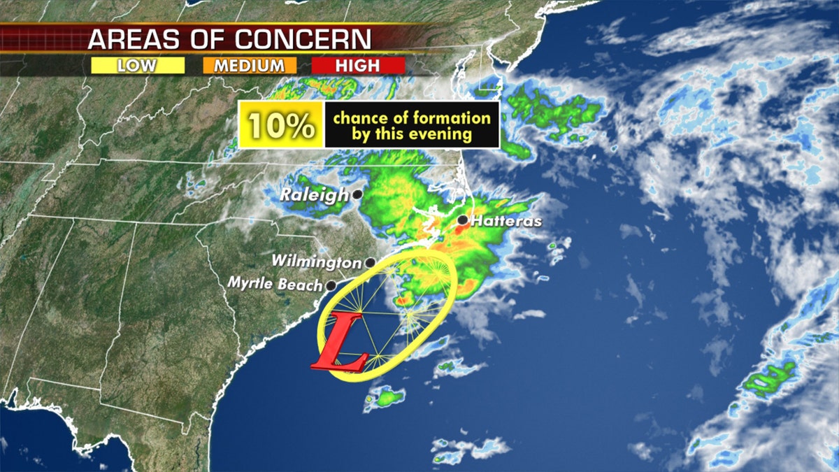
There is a slight chance of tropical development over the next 5 days. (Fox News)
Regardless of development, heavy rainfall is still expected over northeastern South Carolina and eastern North Carolina.

A stalled weather pattern is expected to bring heavy rain through Wednesday for coastal parts of North Carolina into Virginia. (Fox News)
This stalled weather pattern also is causing temperatures to be well below average for the Carolinas and Virginia.

A stalled weather pattern is expected to bring heavy rain through Wednesday for coastal parts of North Carolina into Virginia. (Fox News)
By Wednesday, this weather system will slowly head north into southern and central Virginia.
CRITICAL WILDFIRE CONDITIONS FOR SOUTHWEST, PLAINS AS SEVERE WEATHER THREAT RETURNS
Between 1 to 2 inches of rain is possible along the Blue Ridge Mountains of western Virginia.

The national forecast for June 16. (Fox News)
Temperatures will rise during the week, but are not expected to return to normal until the weekend.
Cool Northwest, snow for the Rockies

Up to a foot of snow is forecast to fall in the northern Rockies as the Northwest sees cool temperatures. (Fox News)
On the other side of the country, the Northwest is also much cooler for this time of the year as another system along with an impressive cold front moves in.

Up to a foot of snow is forecast to fall in the northern Rockies as the Northwest sees cool temperatures. (Fox News)
The higher elevations of Idaho and Montana could get over a foot of snow where winter storm watches are in effect.
CLICK HERE FOR MORE WEATHER COVERAGE FROM FOX NEWS
Travel could be difficult through Wednesday morning, as hazardous backcountry conditions also are expected, according to the National Weather Service (NWS).
Fire danger simmers out West

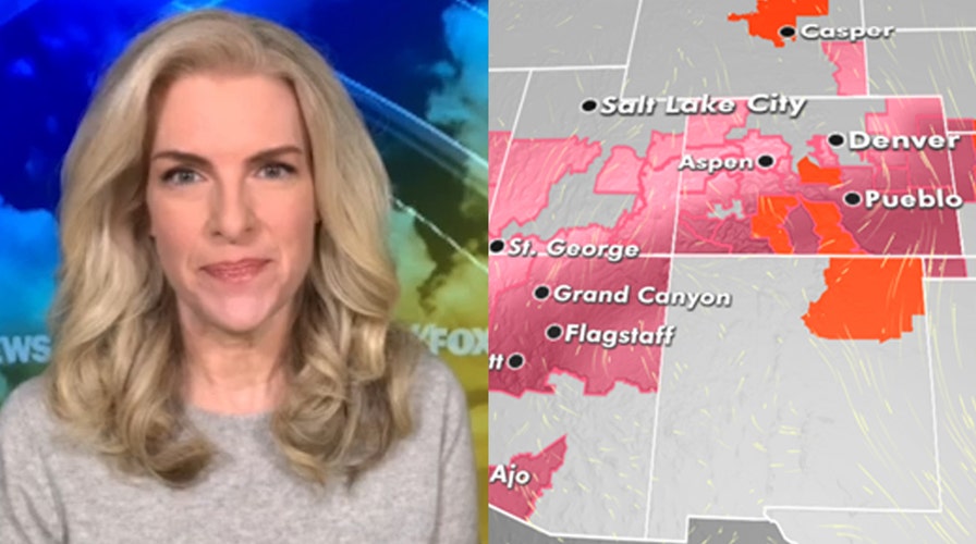
The fire threat continues across the Southwest and into the Plains on Tuesday. (Fox News)
Over the Southwest, elevated to critical fire weather persists on Tuesday due to very dry, windy and hot weather.
CLICK HERE FOR THE FOX NEWS APP
Red-flag warnings are up for parts of Nevada to the high plains of eastern Colorado and western Kansas.
Fox News' Brandon Noriega contributed to this report.

True Crime
The hottest stories ripped from the headlines, from crime to courts, legal and scandal.
By entering your email and clicking the Subscribe button, you agree to the Fox News Privacy Policy and Terms of Use, and agree to receive content and promotional communications from Fox News. You understand that you can opt-out at any time.
