Hurricane Laura: National Hurricane Center director warns of areas that are ‘not survivable’ when hit
Ken Graham, Director of the National Hurricane Center, walks through the latest forecasting of Hurricane Laura, set to wreak havoc in Texas and Louisiana Wednesday night through Thursday morning. He warns of the potentially devastating impact it could have on those along the Gulf Coast and urges residents in danger zones to evacuate before it’s too late.
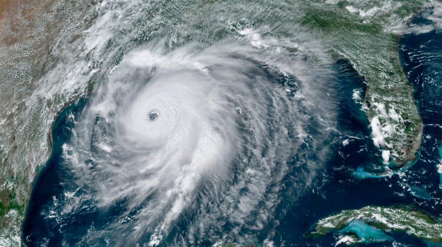
Tropical storm force winds and heavy rains arrived along Louisiana’s central coastline Wednesday evening as the tide came in, hours ahead of the "extremely dangerous" Hurricane Laura’s expected overnight landfall, which is forecast to bring a “catastrophic” storm surge.
The shifting tide and incoming storm surge were expected to cause flooding along the Gulf Coast, the National Weather Service warned Wednesday evening.

A cemetery along Privateer Blvd. in Barataria, La. is inundated in water as water levels surge before Hurricane Laura, Wednesday, Aug. 26, in Barataria, La. (Max Becherer/The Advocate via AP)
As of 11 p.m. ET, the Category 4 storm was about 75 miles south of Lake Charles, La., and southeast of Port Arthur, Texas, moving north-northwest at 15 mph with maximum sustained winds of 150 mph, according to the weather service.
Dating back to 1851, only four hurricanes on record have sustained winds of 150 mph or more as far north in the Gulf, according to Colorado State University meteorologist Philip Klotzbach.
"No significant change in strength is likely before landfall," according to the NWS, and Laura is expected to undergo "rapid weakening" once it moves inland.
Hurricane-force winds will arrive once the storm moved within 60 miles of the coast.
The NWS also reported possible tornadoes appearing in Laura’s outer bands over southeastern Louisiana and the southwestern corner of Mississippi at 9 p.m. ET.
Landfall is estimated near the Louisiana-Texas state line late Wednesday night or early Thursday morning, with Louisiana Gov. John Bel Edwards saying it could happen “just after midnight” in an interview on “Your World” Wednesday afternoon.
HURRICANE LAURA, NOW CATEGORY 4, MAY BRING 'UNSURVIVABLE' STORM SURGE TO TEXAS-LOUISIANA BORDER
“The storm surge is going to be a huge threat to life,” he said. “And in fact, the National Weather Service took the unprecedented step of saying the storm surge is going to be unsurvivable.”
The weather service estimated storm surges of up to 15 to 20 feet directly in the storm’s path. To the east and west, they were expected to be smaller, but still significant. The coastline between Port Bolivar, Texas, and Intracoastal City, La., was expected to have surges of up to 10 feet.
CLICK HERE FOR MORE WEATHER COVERAGE FROM FOX NEWS
“The combination of a dangerous storm surge and the tide will cause normally dry areas near the coast to be flooded by rising waters moving inland from the shoreline,” the National Hurricane Center warned.
“The deepest water will occur along the immediate coast near the landfall location, where the surge will be accompanied by large and destructive waves. Surge-related flooding depends on the relative timing of the surge and the tidal cycle, and can vary greatly over short distances.”
Port Arthur, Texas, has a 15-foot sea wall protecting the city, which lies directly in the storm’s path. Authorities worry the wall may not be enough; the next high tide is expected early Thursday morning, just hours after the storm’s predicted landfall.
Flash flooding along streams and in urban areas are expected Thursday afternoon in eastern Texas, through Louisiana and into Arkansas, the weather service warned. Flooding along freshwater rivers also is expected.
The storm surge could reach inland to 40 miles, according to the weather service. The water from the surge could take days for to recede, the weather service warned.
STORM SURGE DURING HURRICANES: WHAT ARE THE AND HOW CAN YOU PREPARE
Laura’s arrival will be almost exactly 15 years after Hurricane Katrina brought devastating flooding to the region in 2005. That storm’s massive surge overwhelmed the levees in New Orleans and flooded the Mississippi coast, leaving more than 1,800 dead.
Several cities directly in the storm's path were urging residents to evacuate.
More than 385,000 residents were told to flee the Texas cities of Beaumont, Galveston and Port Arthur. Another 200,000 were ordered to leave low-lying Calcasieu Parish in southwestern Louisiana, where forecasters said as many as 13 feet of storm surge topped by waves could submerge whole communities.
Energy companies also evacuated oil and gas platforms in the Gulf of Mexico and shut down coastal refineries. But while some oil production would be hindered by the storm, experts said fuel shortages for American consumers would be unlikely.
CLICK HERE FOR THE FOX NEWS APP
National Guard units in both Texas and Louisiana also prepared Wednesday to aid first responders by land, air and water, authorities said. They are equipped with hundreds of high-water vehicles, dozens of boats and aircraft as well as massive stockpiles of drinking water and military rations.
“Louisiana National Guard has more than 3,000 guardsmen ready to provide support to civilian authorities and has 921,000 liters of water and 528,000 MREs (meals ready to eat) to support citizens, if needed,” Maj. Noel Collins said.
Army and Air Force installations also started moving personnel and equipment due to the storms.

Guardsmen with 256th Infantry Brigade Combat Team conduct refresher boat training in Lake Charles, La., Aug. 25, ahead of Hurricane Laura’s landfall in southwest Louisiana. (Photo by Louisiana National Guard)
The Air Force’s 53rd Weather Reconnaissance Squadron Hurricane Hunters, known for flying into storms to collect vital data, relocated operations from Keesler Air Force Base in Mississippi to the Atlantic Aviation Charleston International Airport in South Carolina ahead of the storm. Aircraft from Eglin, Keesler and New Orleans also were moved in advance. Additional aircraft from Joint Base Ellington Field and Barksdale Air Force Base were beginning to move out Wednesday.

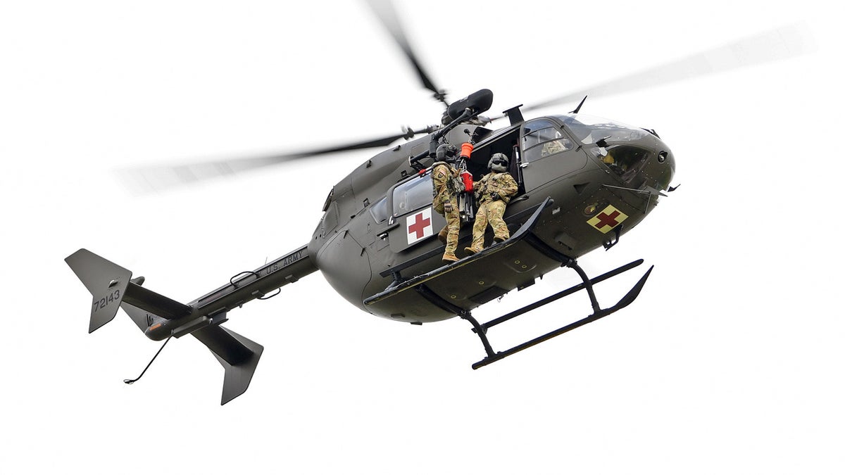
Louisiana National Guardsmen from Delta Company, 2-151st Aviation Regiment conduct recertification training on a LUH-72 Lakota helicopter hoist system used for rescue operations at the Hammond Regional Airport ahead of Hurricane Laura, Aug. 25. Guardsmen continue to prepare to respond to the citizens of Louisiana prior to landfall of Hurricane Laura. (U.S. Air National Guard photo by Master Sgt. Toby Valadie)
The Army repositioned more than 4,500 soldiers from Fort Polk’s training areas to more secure buildings in the main post and was transferring its aviation assets to Fort Bragg in North Carolina, according to Lt. Col. Mary Ricks, an Army spokesperson. The recruiting station in Lake Charles, near the Texas-Louisiana border where Laura is expected to land, also evacuated all recruiters and their families.
Vice President Mike Pence brought up the storm during his speech at the Republican National Convention Wednesday night, urging residents to listen for storm warnings and to follow evacuation instructions, and saying that the Federal Emergency Management Agency was prepared with resources and supplies.
“This is a serious storm, and we urge all those in the affected areas to heed state and local authorities,” he said. “Stay safe and know that we’ll be with you every step of the way to support, rescue, respond and recover in the days in weeks ahead. That’s what Americans do.”
Fox News’ Travis Fedschun, Jennifer Griffin and the Associated Press contributed to this report.


