An area of low pressure hanging out across the Great Lakes will bring cold air and wintry weather to the northern tier of the country this week.
SEVERE STORM DAMAGES BUILDINGS IN FLORIDA PANHANDLE
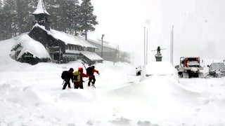
The Northern Plains, parts of the Rockies and the Midwest will see a snowy pattern with the potential for measurable snow over the next few days.

Colder than average temperatures are expected.
On Friday, there’s the chance of a heavy snow event for parts of the Northeast.

At least a foot of snow is expected to drop in the Rockies.
Meanwhile, warmer-than-average temperatures are expected in the Gulf Coast and the South.

Cold air will bring cool temperatures across parts of the Northern Plains, Rockies and Midwest this week.
Showers and thunderstorms will pop up over Texas on Monday, and the Mississippi Valley on Tuesday.

Warm temperatures are forecast across the South and the Gulf Coast for Monday, while it will be cooler than average parts of the Northern Plains and the Rockies.
Some of these storms could reach severe limits.

Drought conditions are expected to remain high in parts of the Southwest and Great Basin this week.
CLICK HERE FOR THE FOX NEWS APP
Low humidity, warm temperatures and breezy conditions have raised the fire danger over the Southwest and the Great Basin for much of this week.


