Hurricane Laura pounding the Gulf Coast with 150 mph winds
Vice Admiral Steve Poulin, Atlantic Area commander, joins Rick Leventhal to discuss the dangers of Hurricane Laura and the U.S. Coast Guard's response.
Hurricane Laura battered the Louisiana and Texas coasts with powerful winds and rain as it made landfall early Thursday as an "extremely dangerous" Category 4 storm.
The hurricane brought a catastrophic storm surge and flash flooding to the southwestern part of Louisiana overnight, according to the National Hurricane Center.
Laura came ashore near Cameron, La., a community of about 400 residents, 30 miles east of the Texas border.
The hurricane came ashore around 2 a.m. ET shattering windows, damaging buildings and leaving more than 290,000 homes and businesses without power in Louisiana and Texas before weakening into a Category 3 storm. The hurricane's maximum sustained winds also weakened to 120 mph by 5 a.m. ET, down from 150 mph when it made landfall.
LIVE UPDATES: HURRICANE WEAKENS INTO CATEGORY 3 STORM AFTER MAKING LANDFALL
A National Ocean Service tide station at Calcasieu Pass in Louisiana said there was a water level rise of more than 9 feet when it made landfall.
A Storm Surge Warning was in effect for High Island, Texas, to the Mouth of the Mississippi River; a Hurricane Warning was in effect for High Island, Texas, to Intracoastal City, La.; and a Tropical Storm Warning was in effect east of Intracoastal City to the Mouth of the Mississippi River as of 5 a.m. ET.
Videos on social media showed Laura’s winds battering a tall building in Lake Charles, La., blowing out windows as glass and debris flew to the ground.
“There are some people still in town and people are calling ... but there ain’t no way to get to them,” Tony Guillory, president of the Calcasieu Parish Police Jury in Louisiana, said early Thursday morning as he hunkered down in a Lake Charles government building that was shaking from the storm.
Guillory said he hopes those stranded can be rescued later Thursday but he fears that blocked roads, downed power lines and flooding could delay that process.
Officials said search and rescue missions will begin as soon as conditions allow.
"TAKE COVER NOW! Treat these imminent extreme winds as if a tornado was approaching and move immediately to the safe room in your shelter. Take action now to protect your life!" the hurricane center warned at 1 a.m. ET.
The safest place to be in a hurricane is in a reinforced room away from the windows. The hurricane center said to take cover under a piece of sturdy furniture and use mattresses, pillows and blankets to protect yourself.
HURRICANE LAURA LIVE UPDATES: GET THE LATEST DEVELOPMENTS HERE
The hurricane center said if the “life-threatening” storm surge occurs during high tide, waters could rise up to 15 feet from Sea Rim State Park, Texas, to Johnson Bayou, La., including Sabine Lake and Rockefeller Wildlife Refuge to Intracoastal City and up to 20 feet from Johnson Bayou, La. to Rockefeller Wildlife Refuge, including Calcasieu Lake.
The center said an “unsurvivable storm surge with large and destructive winds will cause catastrophic damage” from Sea Rim State Park in Texas to Intracoastal City in Louisiana, moving up to 40 miles inland. Flood water won’t fully recede for several days.
“This is a life-threatening situation,” the center said Wednesday evening. “Persons located within these areas should take all necessary actions to protect life and property from rising water and the potential for other dangerous conditions. Promptly follow evacuation and other instructions from local officials.”
Laura was moving north north-west and a turn northward was expected overnight, a path the hurricane center said Laura will likely continue Thursday before moving northeast Thursday evening into Friday.
CLICK HERE TO GET THE FOX NEWS APP
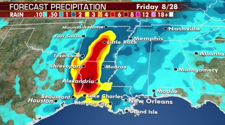
Laura’s eye is expected to move through northwestern Louisiana on Thursday, through Arkansas Thursday night and over the mid-Mississippi Valley on Friday as it rapidly weakens.
The Associated Press contributed to this report.


