


National forecast for Thursday, May 21
Fox News senior meteorologist Janice Dean has your FoxCast.
Get all the latest news on coronavirus and more delivered daily to your inbox. Sign up here.
Residents near a dam in southwest Virginia were ordered to evacuate early Thursday after a slow-moving storm system brought flash flooding across the region as more "significant" flooding is in the forecast.
The National Weather Service (NWS) office in Blacksburg said that as of 6 a.m. Thursday, 4.61 inches of rain had fallen in Roanoke over 48 hours.
"It doesn't take a tropical-named storm to cause a lot of damage and flooding, and that's exactly what we're seeing here across the Mid-Atlantic for another day or so into tomorrow, into Friday," Fox News senior meteorologist Janice Dean said Thursday on "Fox & Friends."
WHAT IS A CUTOFF LOW? WHY THESE STALLED SYSTEMS CAN CREATE HAZARDOUS SITUATIONS
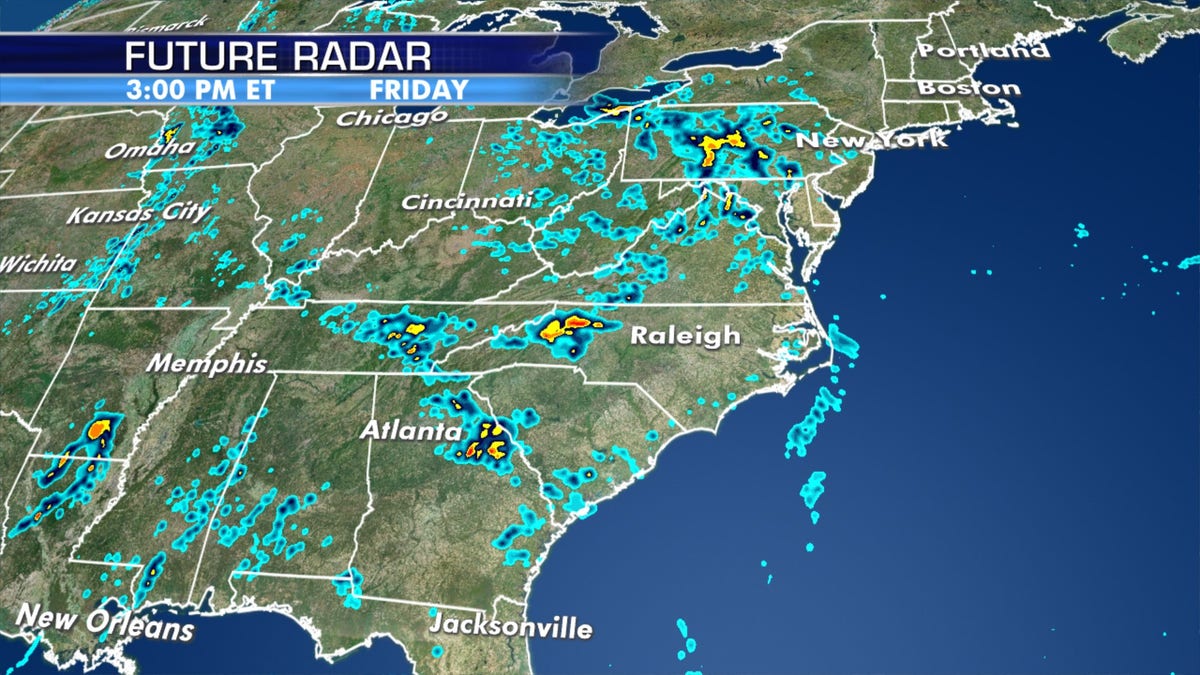
Between 1.5 and 3 inches of rain, with some localized 4- to 5-inch amounts, fell across the region Monday afternoon into Tuesday night. Up to 5 inches, with locally heavy amounts, is forecast through Friday.
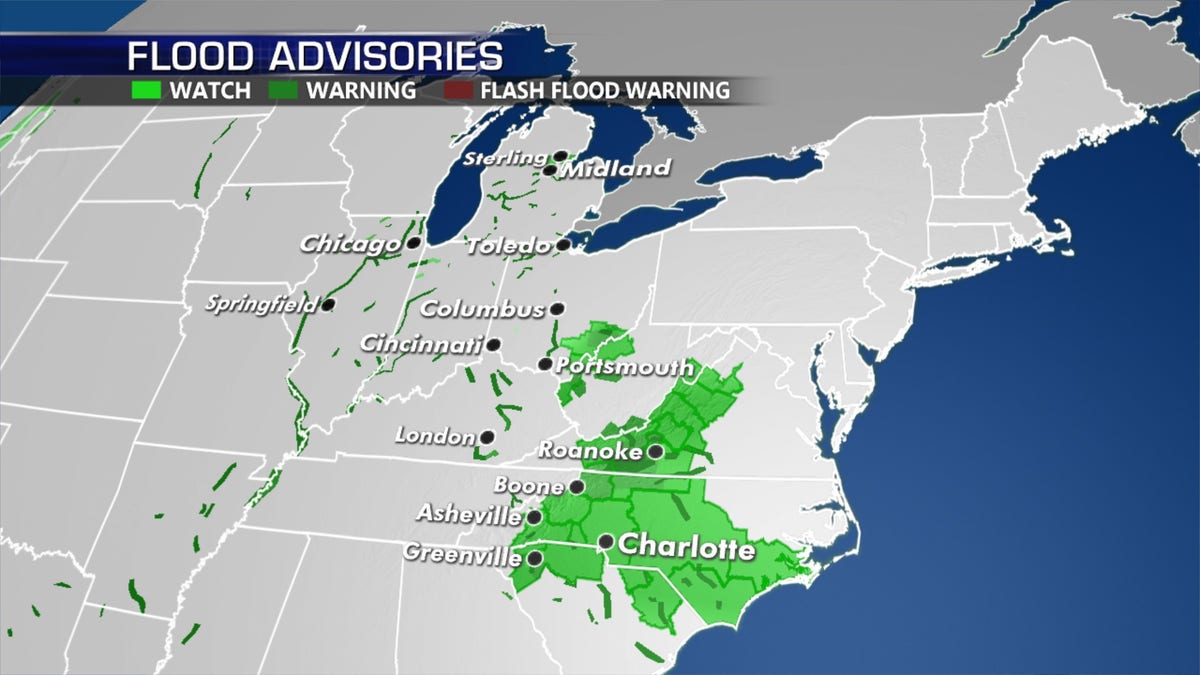
Flood warnings, watches, and advisories are posted from the Ohio River Valley to the Mid-Atlantic after a stalled storm system brought heavy rain over the region this week. (Fox News)
"Areas of flooding and localized flash flooding will continue or worsen today as an additional one to four inches of rain fall," the NWS office tweeted. "This will result in more water covered roads, so please Turn Around Don't Drown!"
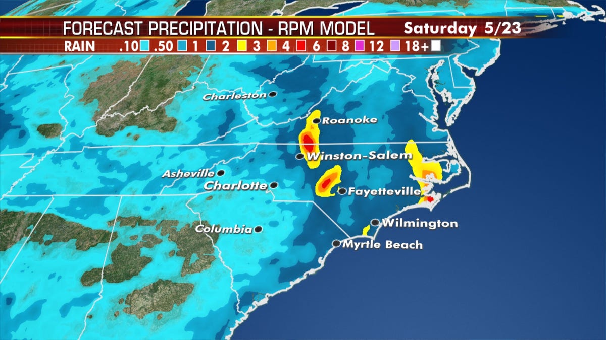
Additional rainfall through Saturday across the region. (Fox News)
The stalled out system bringing the heavy rain to the Mid-Atlantic is caused by a "cutoff low," a low-pressure system that remains stationary for several days after getting cut off from the jet stream.
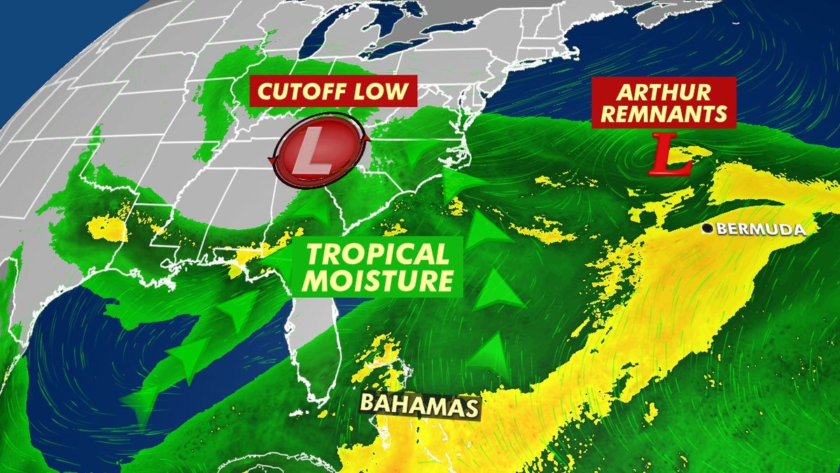
A cutoff low is tapping into moisture across the Southeast from Tropical Storm Arthur. (Fox News)
This stalled area of low pressure also is tapping into tropical moisture, which was already in place across the region due to Tropical Storm Arthur near the coast earlier this week.
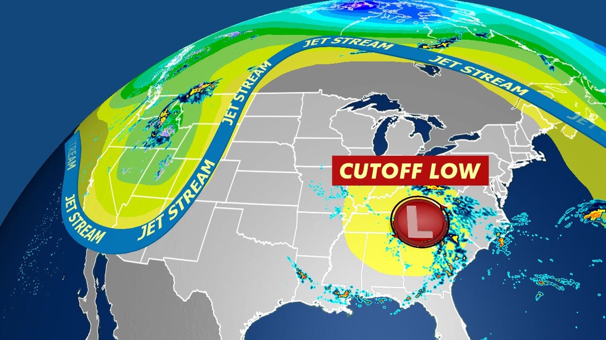
Without the steering of the jet stream, what is known as a "cutoff low" can remain stationary for days or even meander in any direction. (Fox News)
From the Appalachians into the Carolinas, flood watches and warnings remain in effect as additional rain and runoff keep the threat of flooding through the region on Thursday.
More heavy rain is forecast to impact the Mid-Atlantic through the end of the week. (Fox News)
The city of Roanoke said that residents living near the Spring Valley Dam were ordered to evacuate early Monday.

As of Thursday morning, emergency crews have responded to at least three swift-water rescues in the Roanoke, Va. due to flooding. (Roanoke Fire-EMS)
"Due to heavy rains, the Spring Valley Dam located in the City of Roanoke near Lake Dr. is in danger of failing, which could cause flooding in the immediate area of the dam," the city tweeted.
Officials said that 13 homes in total were affected by the evacuation, as personnel from Roanoke Fire-EMS were going door-to-door to evacuate residents and ask them to move to higher ground.
SWOLLEN MICHIGAN RIVER CRESTS AS WHITMER, OFFICIALS WARN FLOOD DANGER ISN'T OVER YET
As of Thursday morning, emergency crews have responded to at least three swift-water rescues in the city.
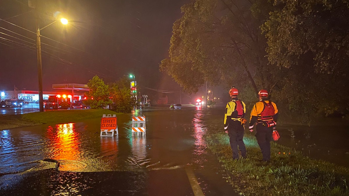
Swift-water rescued have been reported in Roanoke, Va. due to flooding. (Roanoke Fire-EMS)
Roanoke Fire-EMS crews said in a series of tweets that crews have responded to cars getting into floodwaters, including some drivers who went around barricades.
"Please be reminded that barricades are in place for a reason," the agency stated. "They are there for yours and our protection."
No injuries were reported as of Thursday morning from the floods in the Roanoke area. The danger for additional flooding continued Thursday, as forecasters from the NWS' Weather Prediction Center (WPC) forecasted more heavy rainfall to the Mid-Atlantic.
CLICK HERE FOR MORE WEATHER COVERAGE FROM FOX NEWS
Forecasters warn that rainfall rates on Thursday will become "excessive," especially within bands of any thunderstorms that develop.
"The storm's seemingly endless supply of moisture, its slow movement, and the region's overly saturated soil are a recipe for significant flooding on Thursday," the WPC said.
CLICK HERE FOR THE FOX NEWS APP
Besides the risk of flash floods, forecasters are also warning about the potential for landslides and debris flows in steeper terrain.
The flooding in Virginia comes as Michigan faces what the state's governor called a "500-year" flood that led to the failure of a dam and evacuation of some 10,000 people on Tuesday night.

True Crime
The hottest stories ripped from the headlines, from crime to courts, legal and scandal.
By entering your email and clicking the Subscribe button, you agree to the Fox News Privacy Policy and Terms of Use, and agree to receive content and promotional communications from Fox News. You understand that you can opt-out at any time.
