


The howling winter winds were so strong Wednesday over the Upper Midwest that blizzard conditions could be picked up from space.
The National Weather Service said a strong storm system and associated Arctic cold created whiteout conditions in parts of the Dakotas and into Minnesota, with winds gusting as high as 45 to 55 mph, creating treacherous travel conditions.
The National Oceanic and Atmospheric Administration shared on Twitter that the blizzard conditions along the North Dakota/Minnesota state line could be seen on a satellite.
WHICH WERE THE WORST BLIZZARDS? HERE ARE THE DEADLIEST STORMS IN HISTORY
The video from NOAA Satellites Public Affairs shows streaks of gray blowing southward, away from the Canadian border.
"The fuzzy gray lines are plumes of snow being lofted into the air and blown southward by strong #winds. #WhiteoutConditions are possible," NOAA Satellites tweeted.
A blizzard warning was issued for the area as travel headaches were reported along the central and southern Red River Valley on Wednesday. In North Dakota, the state's Department of Transportation said Interstate 29 was closed for several hours from the South Dakota border to the Canadian border due to blizzard conditions.
NOAA Satellites reiterated that a blizzard warning does not always require falling snow. A blizzard has a unique definition with weather thresholds that must all be met for at least three straight hours.
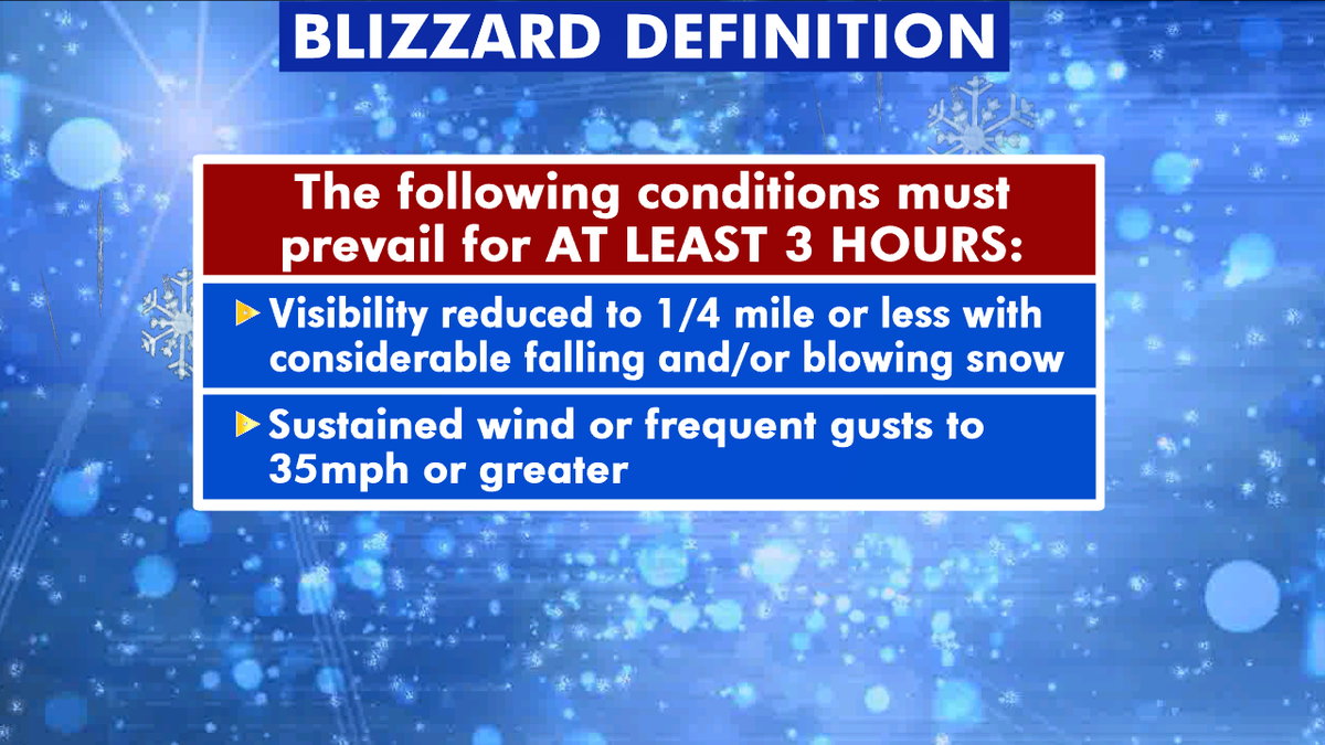
These are the conditions for what is called a blizzard. (Fox News)
In order to be a blizzard, there must be sustained or frequent wind gusts of 35 miles per hour or greater in addition to having considerable falling/and or blowing snow that reduces visibility below a quarter-mile.
CAN IT BE TOO COLD TO SNOW? WHY LIFTING OF AIR MATTERS
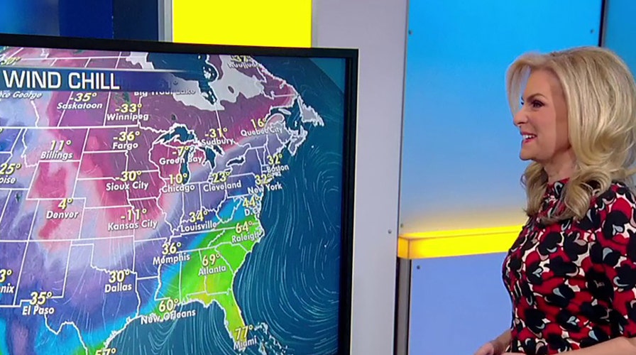
The Arctic cold front that brought the blizzard conditions to the Northern Plains and Upper Midwest moved into the Midwest and Great Lakes, where dangerous wind chills are spreading south and east, according to Fox News Senior Meteorologist Janice Dean.

Dangerously cold wind chills were reported Thursday across the Upper MIdwest. (Fox News)
"It's cold out there across the Upper Midwest and the Great Lakes," Dean said Thursday on "Fox & Friends." "We got this Arctic cold front that's moving through, bringing minus-40 windchills across portions of the Upper Midwest and the Northern Plains."
Dean said the cold front is going to be off the East Coast by Friday, where temperatures will be moderate but still chilly through Saturday.
CLICK HERE FOR MORE WEATHER COVERAGE FROM FOX NEWS
Ahead of the front is where there could be some moisture on Thursday, according to Dean.

Once the storm system moves east, bitter cold is forecast to follow. (Fox News)
"Some heavier rain showers and some snow across the Great Lakes," Dean said on "Fox & Friends." "The big story today is cold."
Fox News' Brandon Noriega contributed to this report.

True Crime
The hottest stories ripped from the headlines, from crime to courts, legal and scandal.
By entering your email and clicking the Subscribe button, you agree to the Fox News Privacy Policy and Terms of Use, and agree to receive content and promotional communications from Fox News. You understand that you can opt-out at any time.
