


National forecast for Wednesday, September 2
Fox News senior meteorologist Janice Dean has your FoxCast.
A strengthening Tropical Storm Nana is forecast to become a hurricane by the time it reaches Belize on Thursday as another tropical system is moving out into the Atlantic.
The U.S. National Hurricane Center (NHC) in Miami said Wednesday that aircraft data from an Air Force Reserve Hurricane Hunter plane shows that Nana continues westward with little change in strength.
The storm system is located about 215 miles east of Belize City, Belize, and is moving west at 16 mph.
Nana is currently packing maximum sustained winds of 60 mph, according to the 2 p.m. EDT advisory from the NHC.

Tropical Storm Nana is seen over the Caribbean on Sept. 2, 2020. (NOAA/GOES-East)
Forecasters from the NHC said Nana is forecast to keep moving westward, with the storm skirting north of the coast of Honduras before approaching Belize early Thursday.

The forecast track of Tropical Storm Nana. (Fox News)
The entire coast of Belize is now under a hurricane warning, while tropical storm warnings are also in effect for Belize as well as Mexico's Yucatan Peninsula from Puerto Costa Maya to Chetumal.
People in Honduras and Guatemala are also warned to closely monitor the storm's progress.
Further strengthening is expected, and Nana is forecast to become a hurricane late Wednesday before it reaches the coast of Belize.
Tropical storm conditions are expected to arrive in Belize, Mexico and Guatemala by Wednesday night. Tropical-storm-force winds extend outward up to 70 miles from the center.
TROPICAL STORM WATCH VS. TROPICAL STORM WARNING: HERE'S THE DIFFERENCE
Strong winds, a "dangerous storm surge" and very heavy rainfall causing flash flooding are likely, according to the NHC.
Up to eight inches of rain is possible for parts of the region. A storm surge up to five feet will also be accompanied by "large and destructive waves," forecasters said.
In the Atlantic Ocean, Tropical Storm Omar is moving away from the U.S and south of Bermuda, with just some rough surf and rip currents to be concerned with along the East Coast.

The forecast track of Tropical Storm Omar. (Fox News)
The storm formed Tuesday but is only expected to be short-lived.
As of Wednesday morning, Omar is located about 350 miles northwest of Bermuda, moving east-northeast at 14 mph with 40 mph winds. The storm is expected to keep moving to the east and weaken by Thursday.

Nana and Omar, two tropical storms, can be seen with their respective forecast tracks. (Fox News)
Nana and Omar are the earliest 14th and 15th named storms on record, beating the 2005 arrivals of Nate on Sept. 6 and Ophelia on Sept. 7, according to Colorado State University hurricane research scientist Phil Klotzbach.
The tropics are active, but no immediate threats to the U.S. over the next 5 days.

Another area of potential tropical development in the Atlantic. (Fox News)
We are watching a tropical wave off the coast of Africa, which could potentially be a threat to the U.S., but we’re many days out from knowing where this system will go.
CLICK HERE FOR MORE WEATHER COVERAGE FROM FOX NEWS
This 2020 season has been active and record-breaking so far, with several storms breaking records for their respective letter for how early they formed.
The recent activity comes as the hurricane season has entered its most active month. The historical hurricane activity climbs through Sept. 10, when it peaks and starts to slowly go back down.
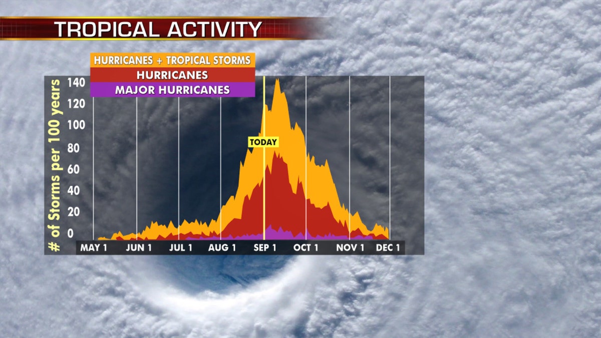
Hurricane season peaks in the month of September. (Fox News)
Historically, about two-thirds of all Atlantic hurricane activity happens between Aug. 20 to Oct. 10, Klotzbach tweeted earlier this month.
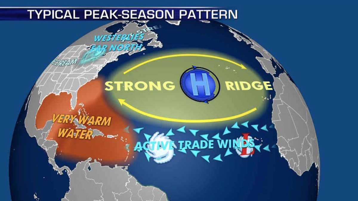
The patterns during the peak of hurricane season that influence where storms travel. (Fox News)
NOAA forecasters are now calling for up to 25 named storms with winds of 39 mph or higher; of those, seven to 10 could become hurricanes. Among those hurricanes, three to six will be major, classified as Category 3, 4 and 5 with winds of 111 mph or higher.

The names of the 2020 Atlantic hurricane season. (Fox News)
That's far above an average year. Based on 1981 to 2010 data, that is 12 named storms, six hurricanes and three major hurricanes. So far this year, there have been 14 named storms, including four hurricanes.
CLICK HERE FOR THE FOX NEWS APP
The 2020 Atlantic hurricane season runs from June 1 to Nov. 30 and includes the names: Arthur, Bertha, Cristobal, Dolly, Edouard, Fay, Gonzalo, Hanna, Isaias, Josephine, Kyle, Laura, Marco, Nana, Omar, Paulette, Rene, Sally, Teddy, Vicky and Wilfred.

Antisemitism Exposed
Fox News' Antisemitism Exposed" newsletter brings you stories on the rising anti-Jewish prejudice across the U.S. and the world."
By entering your email and clicking the Subscribe button, you agree to the Fox News Privacy Policy and Terms of Use, and agree to receive content and promotional communications from Fox News. You understand that you can opt-out at any time.