


South China Sea conflict explained
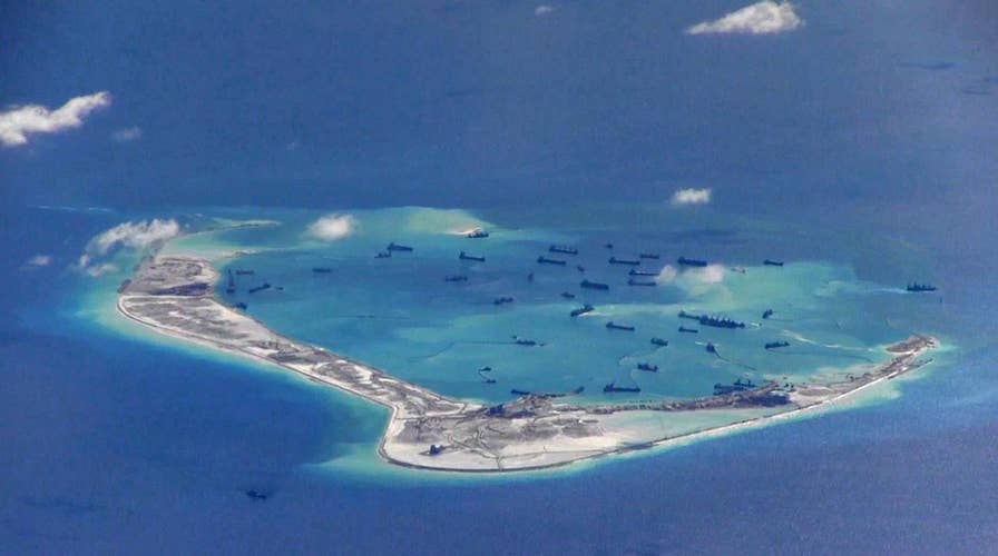
Tensions in the South China Sea are growing as China rapidly develops man-made islands in the critical waterway. Fox News explains the conflict in the region and why the U.S. is paying close attention
China appears to have constructed a new platform at a remote part of the disputed South China Sea that could be used for military purposes, according to satellite images reviewed by a U.S. think tank on Tuesday.
The Asia Maritime Transparency Initiative of Washington’s Center for Strategic and International Studies said the "modest new structure" appears to be anchored on Bombay Reef, and is topped by solar panels and a radome. A radome is an enclosure that protects radar equipment.
"The development drew attention given Bombay Reef’s strategic location, and the possibility that the structure’s rapid deployment could be repeated in other parts of the South China Sea," the group said in its report.
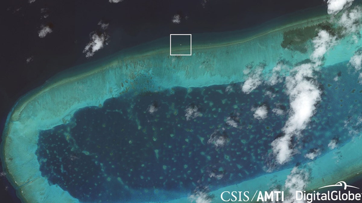
The new structure on Bombay Reef has been spotted in satellite photos. (CSIS/AMTI)
Bombay Reef, a remote, undeveloped outcropping, is located on the southeastern edge of the Chinese-controlled Paracel Islands in the South China Sea. Vietnam and Taiwan also claim the reef, which already has a lighthouse to serve as an aid to navigation. The new platform first appeared at the reef in satellite imagery dated July 7, 2018, and was not present in earlier shots from April.
Unlike China's large man-made islands created by piling sand on top of coral reefs, installing the modestly-sized Bombay Reef platform did not mean inflicting major environmental damage, CSIS said. The installation, however, shows how easily China could expand its footprint to other features such as Scarborough Shoal, which it seized from the Philippines in 2012, it added.
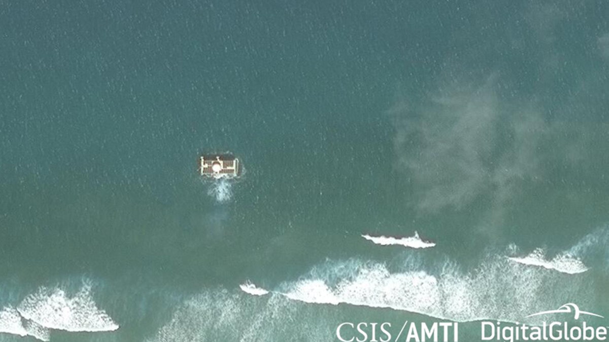
The Asia Maritime Transparency Initiative of Washington’s Center for Strategic and International Studies said it's likely the purpose of the platform is "military in nature." (CSIS/AMTI)
"The more likely possibilities, given Bombay Reef’s strategic location, are military in nature," the group said in its report. "The reef is directly adjacent to the major shipping lanes that run between the Paracels and the Spratly Islands to the south, making it an attractive location for a sensor array to extend Chinese radar or signals intelligence collection over that important sea lane."
CHINA, US SPARRING CONTINUES OVER SOUTH CHINA SEA
Chinese Foreign Ministry spokesman Geng Shuang said Wednesday at a daily news briefing in Beijing that he had no information about the details of the report, while reasserting China's claims to the island group it calls Xisha, according to the Associated Press.

Pentagon warns against military buildup in South China Sea
The latest U.S. military moves against Chinese expansion serves as back drop to potential North Korea talks. Jennifer Griffin shares details for 'Special Report.'
"The Paracel Islands are China's territory. This is indisputable. China's construction on its own territory is beyond reproach," Geng said.
On Wednesday, the USS Ronald Reagan docked in Hong Kong days after a pair of American B-52 bombers flew over the disputed South China Sea. The recent tensions come ahead of a planned meeting later this month between President Trump and Chinese leader Xi Jinping.
In late September, a Chinese destroyer came close to the USS Decatur in the South China Sea in what the U.S. Navy called an "unsafe and unprofessional maneuver."
US BOMBERS FLY OVER S. CHINA SEA AHEAD OF CARRIER'S ARRIVAL
Why China is a bigger problem for U.S. than Russia
According to most of the press, America has only one real enemy: Russia. But the truth may be more complicated. The biggest threat to America isn't Vladimir Putin, but Xi Jinping's regime in China. #Tucker
Rear Adm. Karl O. Thomas, commander of Carrier Strike Group 5, said Wednesday that the "vast majority of our interactions out there at sea are very professional."
"That was a rare, unusual occurrence," Thomas told reporters at a ship-board news conference. "In that particular case, the ship made some aggressive, continuing aggressive maneuvers and our ship warned them and had to maneuver to prevent a collision. It was unfortunate and I'd like to see that not happen again."
The Associated Press contributed to this report.

Antisemitism Exposed
Fox News' Antisemitism Exposed" newsletter brings you stories on the rising anti-Jewish prejudice across the U.S. and the world."
By entering your email and clicking the Subscribe button, you agree to the Fox News Privacy Policy and Terms of Use, and agree to receive content and promotional communications from Fox News. You understand that you can opt-out at any time.