


Fox News Flash top headlines for December 14
Fox News Flash top headlines are here. Check out what's clicking on Foxnews.com.
An active storm pattern is setting up across the East Coast this week, with the first system bringing locally heavy rain for the Mid-Atlantic and coastal areas on Monday. It may then bring in some snow, as cold air arrives on the back side of the system for the Appalachians and interior sections of the Northeast.
This storm will set up a colder air mass in anticipation for Wednesday/Thursday’s potential blockbuster.
'SIGNIFICANT WINTER STORM' ON TRACK TO IMPACT THE MID-ATLANTIC AND NORTHEAST
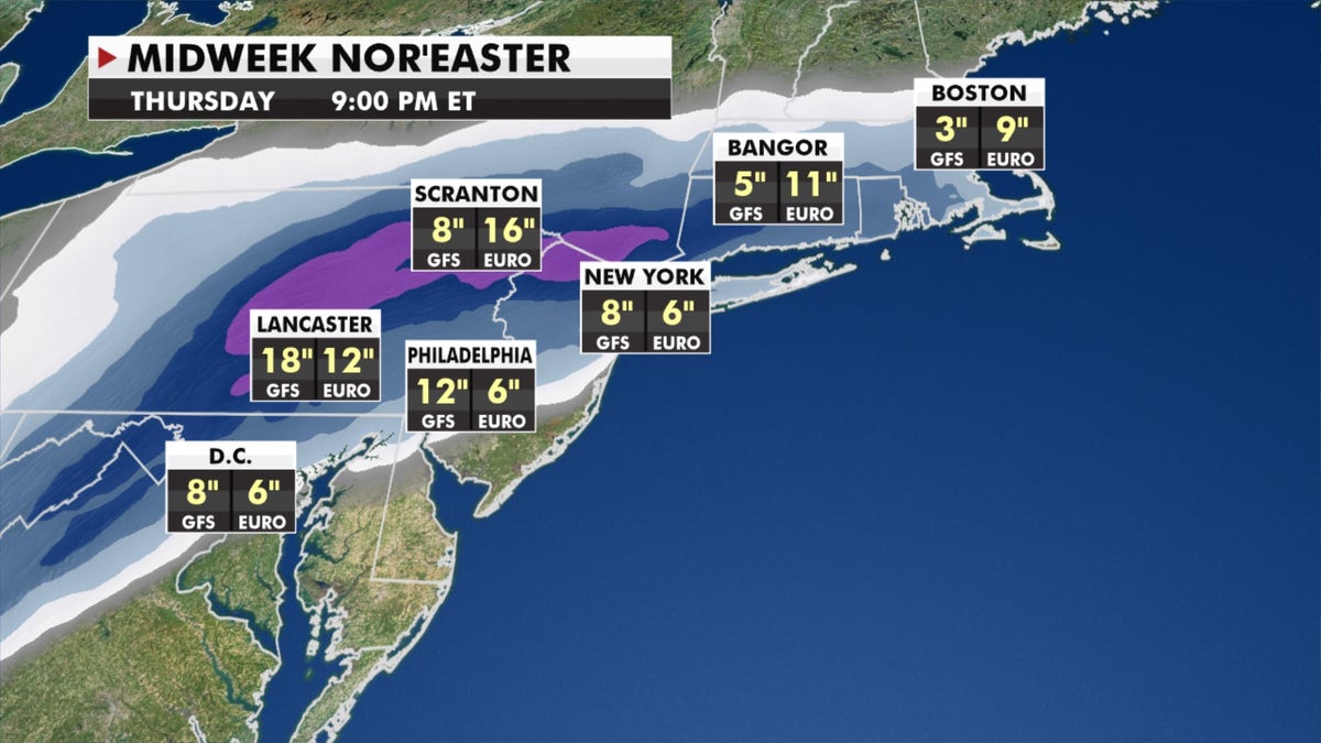
Midweek Nor'easter forecast. (Fox News)
Light snow moves into the West and Central Rockies spreading into the plains Tuesday. Some spots could receive up to 4 inches of snow for parts of Kansas, Nebraska and Oklahoma.
CLICK HERE TO GET THE FOX NEWS APP

Forecast for Dec. 14, 2020. (Fox News)
Energy from this system will help develop our nor’easter midweek off the Southeast Coast. A wintry mix will impact North Carolina in the morning, and then rain/freezing rain, sleet and plowable snow will move into the region later in the day for the Mid-Atlantic and Northeast.
Forecast models are still in disagreement with the exact track, timing and how much snow folks could get, but the I-95 corridor should prepare for measurable snow with parts of the interior regions getting plowable snowfall which could disrupt travel.

True Crime
The hottest stories ripped from the headlines, from crime to courts, legal and scandal.
By entering your email and clicking the Subscribe button, you agree to the Fox News Privacy Policy and Terms of Use, and agree to receive content and promotional communications from Fox News. You understand that you can opt-out at any time.
