Hurricane Zeta to make landfall on Gulf Coast
Strengthening storm forecast to make landfall south of New Orleans.
A reenergized Hurricane Zeta is taking aim at the U.S. Gulf Coast on Wednesday and is expected to become even stronger before it makes landfall in Louisiana.
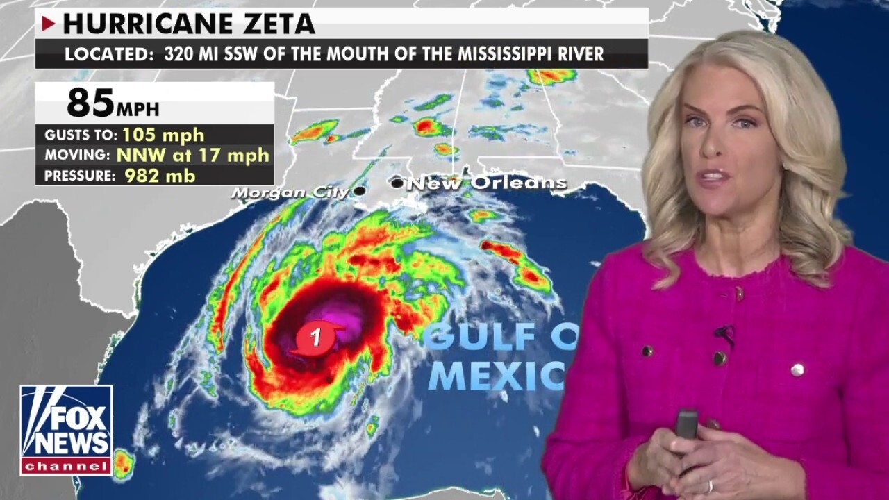
The National Hurricane Center (NHC) said that Zeta is packing maximum sustained winds of 100 mph and is located about 155 miles south-southwest of New Orleans, moving north-northeast at 20 mph. The latest advisory from the NHC notes that an Air Force "Hurricane Hunter" aircraft finds that Zeta is growing stronger hours before landfall.
"Zeta is getting stronger and we are anticipating a Category 2, a strong Category 2 moving into eastern Louisiana and western Mississippi later on this afternoon," Fox News senior meteorologist Janice Dean said on "Fox & Friends." "National Hurricane Center has found winds much stronger than originally anticipated."
ZETA RE-STRENGTHENS INTO A HURRICANE, EXPECTED TO BRING A LIFE-THREATENING STORM SURGE TO LOUISIANA
The system is now expected to make landfall as a strong Category 2 storm south of New Orleans, which will bring life-threatening storm surge, flooding rainfall, damaging winds, and isolated tornadoes. The dangers will also spread inland, as dangerous winds will reach across the Southeast.
"Wind gusts could be especially severe across the southern Appalachian Mountains on Thursday," the NHC said
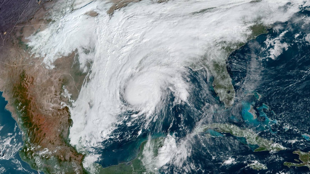
Hurricane Zeta can be seen over the Gulf of Mexico on Wednesday, Oct. 28, 2020. (NOAA/GOES-East)
Hurricane warnings are now in effect from Morgan City, La.. to the Mississippi/Alabama border, including the New Orleans metropolitan area.
"This one I'm concerned with new Orleans," Dean said. "We are going to see higher storm surge totals than originally anticipated."

Hurricane and tropical storm warnings as Hurricane Zeta approaches the Gulf Coast. (Fox News)
Hurricane-force winds extend outward up to 35 miles from the center of the storm, while tropical storm-force winds reach up to 150 miles.
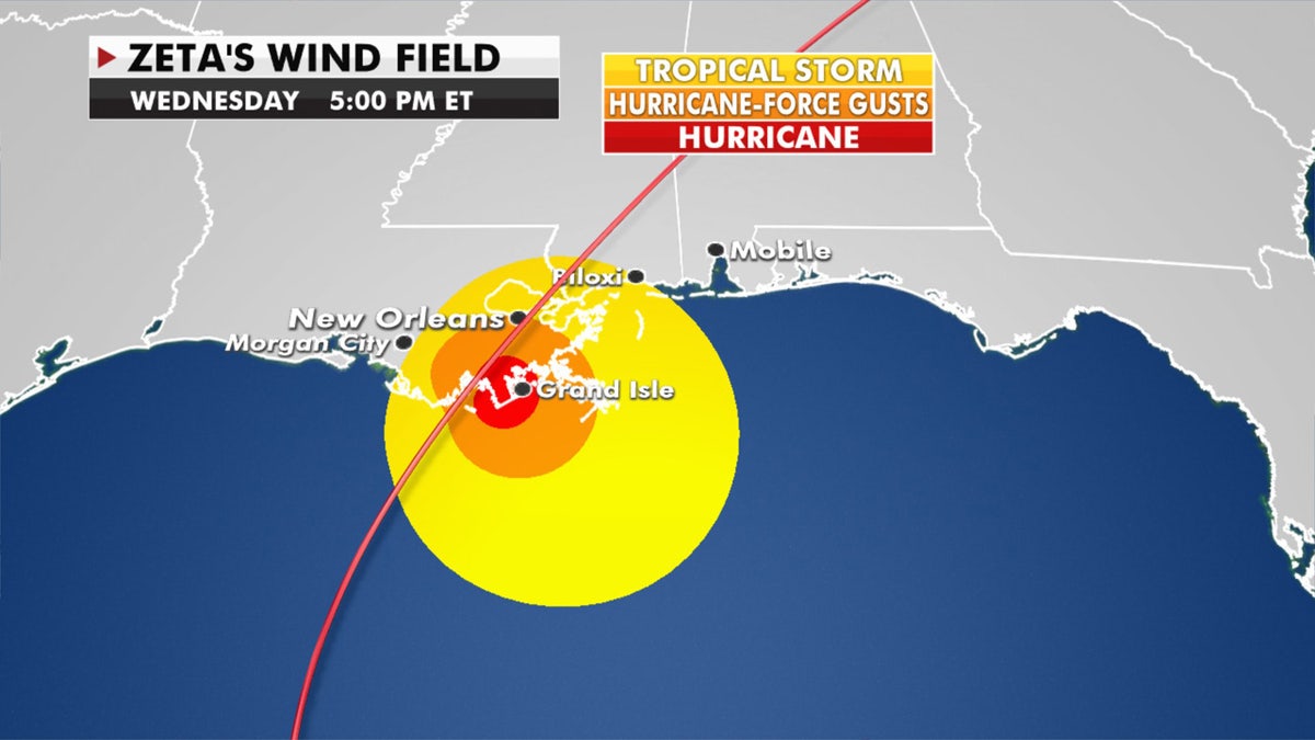
The wind field of Hurricane Zeta as the storm approaches the Gulf Coast. (Fox News)
Winds and heavy rain are moving onto the coast as the hurricane-force winds and storm surge arrive by the mid-afternoon hours.
A "dangerous" storm surge of 5 to 9 feet is possible in areas along the Louisiana, Mississippi and Alabama coasts, with the tidal cycle including how high the water goes, according to the NHC.
LIVE UPDATES: ZETA TAKES AIM AT US GULF COAST
Zeta has already been producing locally heavy rains ahead of the storm, but more downpours can be expected as the storm makes landfall. Between 2 to 4 inches of rain, with isolated amounts of up to 6 inches are possible from the central Gulf Coast through the Mid-Atlantic on Thursday.

Forecast rainfall amounts of Hurricane Zeta. (Fox News)
The greatest risk of tornadoes is expected through Wednesday night over southeastern parts of Louisiana and Mississippi, southern Alabama, and the western Panhandle of Florida.
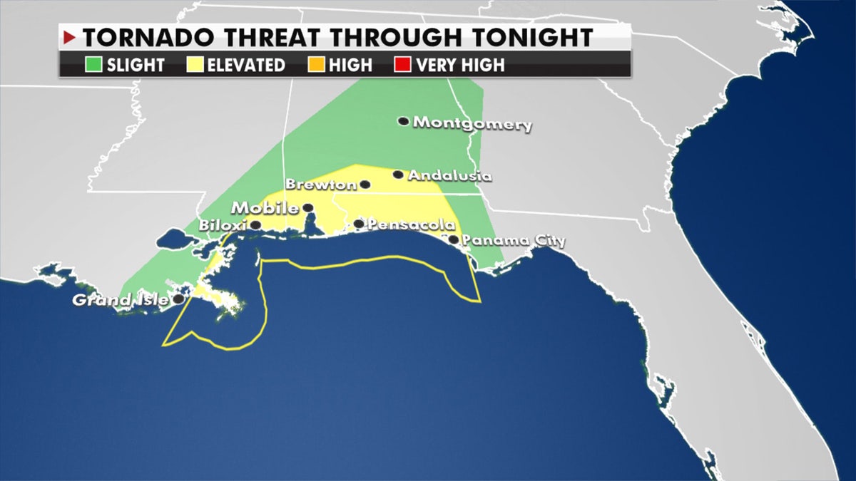
The greatest risk of tornadoes from Hurricane Zeta. (Fox News)
The system will move quickly as it interacts with another system from the West, moving along the Mississippi coast by Wednesday night and across the southeast on Thursday.

Flood advisories stretch inland from Hurricane Zeta. (Fox News)
Even though Zeta will lose its tropical characteristics as it races northeastward, it will still bring very strong winds and even some snow on the backside of the storm as it arrives in the Northeast on Friday.
"Damaging winds, especially in gusts, will spread well inland across portions of southeastern Mississippi, Alabama, and northern Georgia this evening through early Thursday morning, and into the Carolinas and southeastern Virginia on Thursday," the NHC said.
HURRICANE WARNING FOR NEW ORLEANS AS ZETA LASHES MEXICO'S YUCATAN PENINSULA
The storm's landfall in Louisiana would be the fifth so far this busy 2020 Atlantic hurricane season. The state has been hit by two tropical storms and two hurricanes this year: Laura, blamed for at least 27 Louisiana deaths after it struck in August, and Delta, which exacerbated Laura’s damage in the same area just weeks later.

Four other named storms have made landfall in Louisiana so far in 2020. (Fox News)
Louisiana Gov. John Bel Edwards asked President Trump for a disaster declaration ahead of the storm. He and Alabama Gov. Kay Ivey both declared emergencies, as did Mayor Andrew “FoFo” Gilich in Biloxi, Mississippi. Trump declared an emergency for Louisiana Tuesday evening.
BEST WAY TO PREPARE FOR A STORM SURGE
“There’s no doubt that we’ve seen a lot this year, with COVID and so many threats from so many storms,” Gilich said in a news release, “but this storm shows that we haven’t seen it all yet."
New Orleans Mayor LaToya Cantrell also issued an emergency declaration ahead of the storm, with a voluntary evacuation order for areas outside of the levee protection system in Orleans Parish.
CLICK HERE FOR MORE WEATHER COVERAGE FROM FOX NEWS
The storm approached as New Orleans officials announced that a turbine that generates power to the city's aging drainage pump system broke down Sunday, with no quick repair in sight. There was enough power to keep the pumps operating if needed but it left authorities with little excess power to tap should a breakdown of other turbines occur, officials said at a news conference.
"This is a stronger storm," Dean said Wednesday morning. "New Orleans, you need to be solidifying your preparations and knowing what you're going to do."
A mandatory evacuation order was issued for Grand Isle, where a new levee has quickly been built after damage from earlier storms this season.

A Plaquemines Parish sheriff deputy walks away after workers closed a floodwall gate on Hwy 39 in Poydras, La., Wednesday, Oct. 28, 2020. (AP Photo/Gerald Herbert)
“Zeta is coming in fast," Mayor David Camardelle told FOX8. "It’s the seventh cone and it’s right on top of us."
Yet another approaching storm added more stress to evacuees from previous hurricanes to strike the state.
The state is sheltering about 3,600 evacuees from Laura and Delta, most in New Orleans area hotels.

Perry Menesses, right, and Will Guillot secure their boat with more rope after hearing that Hurricane Zeta has increased in strength, in Violet, La., Wednesday, Oct. 28, 2020. (AP Photo/Gerald Herbert)
“I’m physically and mentally tired,” Yolanda Lockett of Lake Charles told the Associated Press from a New Orleans hotel.
CLICK HERE FOR THE FOX NEWS APP
Residents in New Orleans said Tuesday they were feeling the storm fatigue but not letting their guard down.
“I’m always worried about the storm. We’ve been through a lot of them after going through Katrina,” Venetian Isles resident Ronald Dufour told FOX8. “With the water up to the roof, I’m always worried. I have very much respect for every storm that comes here in the Gulf it seems like the last seven were all pointed at us.”
The Associated Press contributed to this report.


