California unveils earthquake warning system
New system sends earthquake warnings through an app and the wireless system that issues Amber Alerts; insight from Richard Allen, director of the UC Berkeley Seismological Lab.
A team of scientists is reportedly working to obtain the sharpest pictures ever taken of the Cascadia subduction zone – a fault line that runs for seven hundred miles off the coast of the Pacific Northwest.
The subduction zone, which has been the site of some of North America's largest earthquakes and the Earth's past "megathrust" earthquakes, has been strangely quiet, with almost no seismic activity detected.
JAPANESE RESEARCHER DIG DEEPEST OCEAN HOLE IN HISTORY
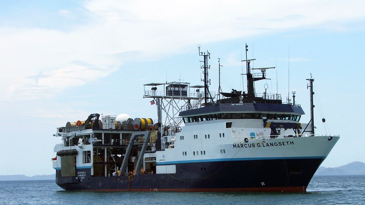
To investigate Cascadia's Oregon and British Columbia portion and the reason for this lull, Columbia University led a team of researchers – including students – from the University of Texas Institute for Geophysics, Woods Hole Oceanographic Institution, University of Washington, Oregon State University and the National Oceanic and Atmospheric Administration (NOAA), which has boarded Columbia's R/V Marcus G. Langseth for the weeks-long expedition funded by the U.S. National Science Foundation.
Science technicians are also present to help operate the seismic equipment as well as marine mammal observers and the Langseth's officers and crew.
"During our cruise, we are using sound to probe under the seafloor looking for the megathrust fault deep beneath several kilometers of sediments that cover the down-going Juan de Fuca plate," Columbia's Bruce C. Heezen/Lamont Research Professor Suzanne Carbotte wrote in a Tuesday post detailing the trip.
"Our survey will be the first-ever seismic imaging study to span almost the entire Cascadia subduction zone. We will be using modern advanced seismic imaging technology to detect and characterize fine-scale structures within the subduction zone to help address a range of scientific questions pertaining to earthquake and tsunami hazards within the Pacific Northwest region," she added.
Carbotte, in an email to Fox News, explained further that the key overarching question is: "Where is the megathrust fault that generates ‘the big one’ buried deep beneath the sediments at Cascadia?"
"Because the fault zone is so quiet seismically, we really don’t have a good picture of where the part of the fault that generates the big earthquakes is located. At other subduction zones, there are many small earthquakes recorded along the megathrust fault that scientists can use to locate the fault and study its properties," she said. "But not at Cascadia."

Research vessel (R/V) Marcus G. Langseth, operated by Lamont-Doherty Earth Observatory's Office of Marine Operations, can deploy several kilometers of cable to collect seismic data from beneath the seafloor. ( Jared Kluesner, USGS Pacific Coastal and Marine Science Center. )
"Earthquakes and fault systems are extremely complex; there are many parameters that can affect earthquake rupture, " U.S. Geological Survey Research Geologist Lydia Staisch told Fox News via email on Thursday. "So, predicting where and when an earthquake will occur is extremely difficult. But what we can do is read the paleoseismic record to understand what past earthquakes were, like, where they occurred and how they impacted specific regions."
She added, "The Cascadia subduction zone has a lot of evidence for past earthquakes, which is cataloged in the stratigraphy along the coast and far offshore. The paleoseismological record helps us gain an understanding of what the range of possible scenarios could be for future earthquakes."
According to Science Mag, the Langseth will use ultrasound technology, emitting sound pulses from a sound source towed behind the ship to construct a detailed image of the subsurface.
Additionally, the team will reportedly use hydrophone microphones and hundreds of other receivers on the ocean floor and land to record echoes and reflections from the fault.
"The level of detail in the images we can acquire with this technology can’t be acquired any other way and there are a whole host of questions that can be addressed only with the high resolution of the structures and properties of the subsurface that we can obtain," Carbotte said Thursday.
Furthermore, she noted in the post that the Cascadia's silence has been assumed to mean the fault is "entirely locked," signaling the potential for a Cascadia megaquake.
"Scientists believe this lack of seismicity reflects the ‘locked’ state of the megathrust fault at present, with strain quietly accumulating as the Juan de Fuca plate system continues to dive (subduct) beneath North America. All or part of that built-up strain will eventually be released in the next great earthquake," she wrote.
In addition to locating the fault, Cabotte said the data the team is acquiring "will be used to characterize the properties of the fault zone which will help us better understand where and why some parts might be creeping slowly now."
While other parts may appear fully locked contributing to the risk of destructive rupture, Carbotte told Fox News that this "kind of information is needed to better constrain earthquake and tsunami hazards along the margin."
CLICK HERE FOR THE FOX NEWS APP
Scientists hope this expedition will help to gain further insight into the matter, including how close to the surface a future rupture could reach, if there are pockets of gas trapped that could make sediments liable to collapse during an earthquake and how quickly airgun waves travel through sediments – particularly useful for improving early warnings.
Science Mag said that movement captured by GPS stations has been reassuring, suggesting that part of the fault is "creeping" and releasing stress and that there's evidence that many large quakes did not rupture the whole fault, but the question of when the next "big one" will strike remains.
"The scientific community cannot predict the time, location, and magnitude of earthquakes to the degree of being of practical use to society," Kelin Wang, Geological Survey of Canada Pacific Geoscience Centre research scientist, wrote to Fox News on Thursday. "The study of earthquakes, including the structural imaging like in this cruise and the study of seismic or geodetic signals that had preceded past earthquakes, allow us to understand the physics of earthquakes – what geological factors control their size, location, recurrence pattern, preparation process, and so forth."


