


Tropical Storm Isaias moves up East Coast, could hit Carolinas at hurricane strength
Mike Tobin reports on the latest from Sullivan's Island, South Carolina.
Inflatable flood protection barriers were set up in Lower Manhattan on Monday as New York City officials are preparing for any possible storm surge from Tropical Storm Isaias.
The National Weather Service (NWS) said that a tropical storm warning is now in effect for the nation's largest city, with the potential for winds gusting up to 70 mph and several inches of rain.
“We are not taking any chances at all,” New York City Mayor Bill de Blasio said Monday.
STORM SURGE DURING HURRICANES: WHAT ARE THEY AND HOW CAN YOU PREPARE
According to the NWS, the potential for one to three feet of storm surge is possible within surge-prone areas with the greatest concern from Tuesday afternoon until Wednesday morning.
In those limited areas, forecasters are advising of "limited impacts," particularly along immediate shorelines and in low-lying spots.

The forecast track of Tropical Storm Isaias. (Fox News)
In his weekly press conference on Monday morning, de Blasio said while the storm's impact “appears to be limited in terms of New York City," Lower Manhattan “is particularly vulnerable in this situation" based on forecasts.
He warned that “we have been surprised before by storms. We’ve been surprised by the way they can change at the last minute," saying that the city is "in a very vigilant state right now."

Construction crews erect temporary barriers on South Street in Lower Manhattan on Monday, Aug. 3, 2020 as Tropical Storm Isaias is forecast to bring impacts to New York City. (Fox News)
"We are not taking any chances at all and for everyone who lived through Hurricane Sandy, you will remember we got a lot more than we bargained for," the mayor added.

Construction crews erect temporary barriers on South Street in Lower Manhattan on Monday, Aug. 3, 2020 as Tropical Storm Isaias is forecast to bring impacts to New York City. (Fox News)
City workers are now installing temporary flood barriers -- large interlocking tubes called Tiger Dams -- along South Street along the city's East River, from South Street Seaport all the way down to Wall Street.
“This is crucial. This is going to help protect the community right around there that got hit very hard in Sandy," de Blasio said, referring to the 2012 superstorm that swamped the area.

Construction crews erect temporary barriers on South Street in Lower Manhattan on Monday, Aug. 3, 2020 as Tropical Storm Isaias is forecast to bring impacts to New York City. (Fox News)
The tubes span nearly a mile and were filled with water from a hydrant, according to the New York Post.

Construction crews erect temporary barriers on South Street in Lower Manhattan on Monday, Aug. 3, 2020 as Tropical Storm Isaias is forecast to bring impacts to New York City. (Fox News)
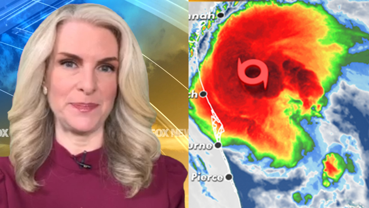
The U.S. National Hurricane Center (NHC) in Miami said the storm now has maximum sustained winds of 70 mph -- just 4 mph shy of officially being a hurricane -- and is located about 220 miles south-southwest of Myrtle Beach, S.C. Isaias is moving north at 13 mph.
CLICK HERE FOR MORE WEATHER COVERAGE FROM FOX NEWS
The latest NHC forecast calls for Isaias to continue its recent strengthening into a hurricane once again before moving into South Carolina by Monday night and then moving quickly north along the Eastern Seaboard through Wednesday.
For Lower Manhattan, the NWS forecasts that winds with 40 to 50 mph with gusts up to 70 mph are possible on Tuesday, with two to four inches of rain that could fall in the city with locally higher amounts.
In the city of Hoboken, N.J. located across the Hudson River from Manhattan and equally as prone to flooding, city officials were prohibiting driving on Tuesday as residents were urged to move their cars from flood hazard areas.
Isaias killed two people in the Caribbean and roughed up the Bahamas but remained at sea as it brushed past Florida over the weekend.
The storm has remained well offshore as it passed Georgia's coast, but is forecast to make landfall in the Carolinas by late Monday.
CLICK HERE FOR THE FOX NEWS APP
Officials in frequently flooded Charleston, S.C., handed out sandbags and opened parking garages so residents in the low-lying peninsula that includes downtown could stow their cars above ground.

Kristin Vadney, with her daughters Evie, 8, right, Amelia, 10, center, and family friend Neely, 10, fills sandbags in preparation for Tropical Storm Isaias Monday, August 3, 2020 at the Virginia Beach Sportsplex, Va. (Stephen M. Katz/The Virginian-Pilot via AP)
Though the center of Isaias was expected to pass Charleston offshore Monday evening, NWS meteorologists said a major flood was possible if rainfall is heavy when the high tide arrives at about 9 p.m.

Joyce Weaver, and others fill their vehicles with sandbags in preparation for Tropical Storm Isaias Monday, August 3, 2020 at the Virginia Beach Sportsplex, Va. (Stephen M. Katz/The Virginian-Pilot via AP)
Those heavy tropical downpours will bring the threat of flash flooding from the Carolinas through the Mid-Atlantic to the Northeast through Tuesday night, as a wide swath of rain with isolated rainfall up to 10 inches, especially across Mid-Atlantic, is expected.
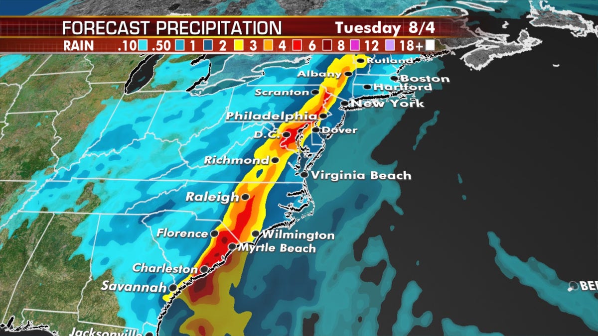
Isaias is forecast to bring a swath of heavy rain stretching northward. (Fox News)
"The potential for heavy rainfall is going to be the legacy of this," Fox News Senior Meteorologist Janice Dean said on "Fox & Friends"
Fox News' Janice Dean, Brandon Noriega, and the Associated Press contributed to this report.

True Crime
The hottest stories ripped from the headlines, from crime to courts, legal and scandal.
By entering your email and clicking the Subscribe button, you agree to the Fox News Privacy Policy and Terms of Use, and agree to receive content and promotional communications from Fox News. You understand that you can opt-out at any time.
