Fox News Flash top headlines for June 22
Fox News Flash top headlines are here. Check out what's clicking on Foxnews.com.
As Tropical Storm Claudette moves offshore, a cold front reaching from the Plains to the Northeast and Mid-Atlantic is expected to bring threats of severe weather and heavy rainfall on Tuesday.
The National Weather Service Weather Prediction Center has issued a slight risk of excessive rainfall with thunderstorms over the southern Mid-Atlantic to the eastern Gulf Coast through Wednesday morning and warned that the heavy rain would create mainly localized areas of flash flooding.
AFTER CAUSING 14 DEATHS, CLAUDETTE HEADS OUT TO SEA
On Wednesday, the agency said, the excessive rainfall threat would lessen as showers and thunderstorms continue over the Gulf Coast and parts of the Southeast into Thursday.

Motorists navigate a flooded Gause Boulevard in Slidell, La., late Friday, June 18, 2021, as a tropical disturbance neared the Louisiana shore. Tropical Storm Claudette has formed Saturday morning along the U.S. Gulf Coast, bringing heavy rains and flooding to coastal states including Louisiana, Mississippi and Alabama. (Scott Threlkeld/The Advocate via AP)
Showers and thunderstorms were also anticipated over the Northern and Central Plains as a weak warm front moves eastward and is forecast to dissipate on Tuesday night and the Storm Prediction Center has issued a slight risk of severe thunderstorms over parts of the Central Plains and the Middle Mississippi Valley through Wednesday morning.
The Upper Midwest is also expected to see showers and thunderstorms on Wednesday and into Thursday as a front moves southward out of South-Central Canada on Wednesday.
The southeast and Gulf Coast are still reeling from the impact of Tropical Storm Claudette, which killed 14 people – including multiple children – and injured others over the weekend before moving east over the Carolinas and out to sea.
A tornado spurred by the tropical storm demolished or badly damaged at least 50 homes in Alabama just north of the Florida border and the system flooded streets and homes there, in Louisiana and along the Mississippi coast.

Percy Ross, left, the owner, watches his son, Michael Roberts, search Ross's flood-damaged home Sunday, June 20, 2021, after the heavy flooding Saturday in Northport, Ala. (AP Photo/Vasha Hunt)
Parts of Georgia reportedly also got heavy rain from Claudette and another tornado touched down in southwestern Early County on Saturday afternoon.
ALABAMA INTERSTATE PILEUP DETAILS EMERGE AFTER 8 GIRLS KILLED ON WAY BACK FROM BEACH TRIP
AccuWeather meteorologists reported on Tuesday that while the risk of flooding will continue over portions of the Gulf Coast already hit by several inches of rain, drier air would bring some humidity relief to areas "near and north of I-20."
But, while heavy rain will once again fall for the eastern half of the U.S., western America – in the midst of a historic drought – will only see conditions alter slightly.

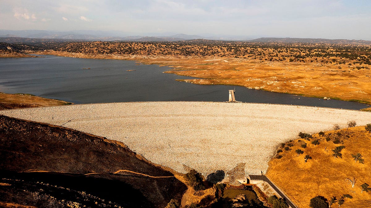
Buchanan Dam holds back water in Eastman Lake on Thursday, June 17, 2021, in unincorporated Madera County, Calif. At the time of this photo, the reservoir was at 11 percent of capacity and 20 percent of its historical average. (AP Photo/Noah Berger)
The National Weather Service said that a plume of moisture would surge into the Southwest and Southern California through Thursday, triggering showers and thunderstorms early Wednesday that would expand into the Great Basin and Rockies through Thursday.
CLICK HERE FOR THE FOX NEWS APP
However, the already fire-ravaged region – spurred by weeks of pervasive and sweltering heat – is also subject to severe dry thunderstorms that the agency said could initiate fire starts in California and the interior Northwest.
Heat and elevated-to-critical fire weather threats will also persist as firefighters work to battle multiple blazes.


