


Fox News Flash top headlines for July 3
Fox News Flash top headlines for July 3 are here. Check out what's clicking on Foxnews.com
Scientists have used satellite imagery to spot an extremely rare "persistent lava lake" on a remote sub-Antarctic island in the South Atlantic.
Researchers from the British Antarctic Survey and University College London trawled satellite data to identify the unusual feature atop the Mount Michael volcano on uninhabited Saunders Island.
The island is part of the South Sandwich Islands, a British Overseas Territory and one of the most remote locations on the planet.
HAWAII VOLCANO: WHY KILAUEA'S LAVA IS CAUSING EERIE BLUE FLAMES
The British Antarctic Survey explains that while there around 1,500 land-based volcanoes on Earth, only a handful have bubbling lava pools in their craters. The Mount Michael lave lake is only the eighth to have been identified worldwide, scientists explain.

An aerial photo of the Mount Michael volcano. (Pete Bucktrout, British Antarctic Survey)
A “geothermal anomaly” was spotted in low-resolution satellite imagery in 2001, prompting further research. A study of higher-resolution satellite data captured between 2003 and 2018, combined with advanced processing techniques, revealed the lava lake.
“We are delighted to have discovered such a remarkable geological feature in the British Overseas Territory,” said Dr. Alex Burton-Johnson of the British Antarctic Survey, in the statement. “Identifying the lava lake has improved our understanding of the volcanic activity and hazard on this remote island, and tells us more about these rare features, and finally, it has helped us develop techniques to monitor volcanoes from space.”
AMAZING ALIEN MINERAL DISCOVERY: SITE OF 60 MILLION-YEAR-OLD METEORITE STRIKE STUNS SCIENTISTS
A paper on the research has been published in the Journal of Volcanology and Geothermal Research.
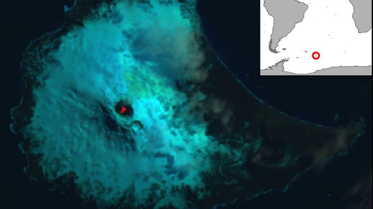
False color Landsat 8 satellite image of Saunders Island and the lava lake within the crater of the Mount Michael volcano. The image was acquired on Jan. 31, 2018. Inset map shows the location of Saunders Island in the South Atlantic. (USGS/NASA/British Antarctic Survey)
The study’s lead author, Danielle Gray of University College London, explained that Mount Michael’s remote location made satellite data invaluable. “It is extremely difficult to access, and without high-resolution satellite imagery it would have been very challenging to learn more about this amazing geological feature,” she said in the statement.
CLICK HERE TO GET THE FOX NEWS APP
The Smithsonian notes that eruptive activity at Mount Michael was not recorded until the early 19th century. The last confirmed eruption at the remote volcano was between August and October 2015, it adds, with “intermittent activity” through September 2018.
Follow James Rogers on Twitter @jamesjrogers
Fox News Artificial Intelligence
Stay up-to-date on the latest AI technology advancements and learn about the challenges and opportunities AI
By entering your email and clicking the Subscribe button, you agree to the Fox News Privacy Policy and Terms of Use, and agree to receive content and promotional communications from Fox News. You understand that you can opt-out at any time.