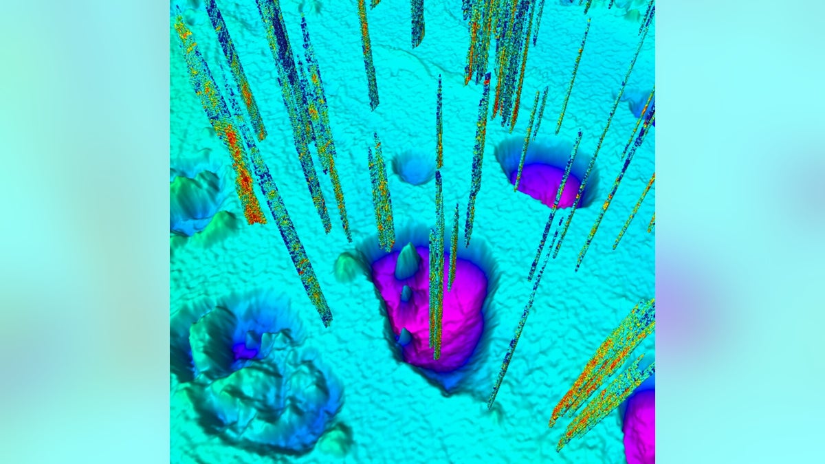
Giant craters along the floor of the Barents Sea were created when methane gases erupted about 11,600 years ago. Today, smaller seeps (vertical lines) still bubble up around the craters. (Andreia Plaza Faverola/CAGE)
Craters as wide as 12 city blocks on the Arctic seafloor were put there by giant eruptions of underground methane gas.
Some of these craters had been discovered in the early 1990s, but only now have scientists mapped the features in detail. Researchers have discovered that there are many more craters than first believed — more than 100 giant ones and perhaps thousands of smaller pockmarks — and that these features probably formed about 11,600 years ago. This happened as the retreat of ice sheets destabilized frozen gas under the seafloor. Some mounds of frozen gas exploded, creating the craters still seen today.
"It's an analog for events that could take place in the future around contemporary ice sheets," said study researcher Karin Andreassen, a marine geologist and geophysicist at the Arctic University of Norway in Tromsø. Methane is a potent greenhouse gas , Andreassen said, so studying these undersea eruptions is important for understanding how they might affect the climate. [ 8 Ways Global Warming Is Already Changing the World ]
Frozen methane
Andreassen and her colleagues were funded through the Research Council of Norway with grant money earmarked for understanding methane release from the seafloor. It's well-known that methane bubbles up from the sediments under the ocean in the Arctic, Andreassen told Live Science, but these small seeps don't reach much higher than 650 feet (200 meters) into the water column above the ocean bottom. The gas dissolves back into the ocean water before it can reach the atmosphere.
Explosive methane eruptions might be much different. Andreassen and her team took the research vessel Helmer Hanssen to the Barents Sea off the northern coast of Norway. The researchers used a variety of techniques, such as collecting seafloor sediment samples. They also beamed acoustic and seismic signals to the ocean floor and subsurface and used the echoes to map the contours below.
The researchers discovered more than 100 giant craters, each up to 0.6 miles (1 kilometer) wide and nearly 100 feet (30 meters) deep, in an area of 170 square miles (440 square km). The scientists also discovered many previously undiscovered mounds, known as pingos . These pingos are lumps of methane hydrate, or methane gas frozen within a lattice of water molecules.
Exploding pingos
It's these pingos that can explode when the conditions are right. Andreassen and her colleagues used mathematical modeling to figure out what kind of pressures, temperatures, water depths and other factors are required to keep the methane hydrate locked in the subsurface, and under what conditions the gas explodes.
Their findings told the story of how the craters came to be. During the icy Pleistocene , which began 2.5 million years ago, an enormous ice sheet more than a mile (2 kilometers) thick covered the Barents Sea. As this sheet ebbed and flowed and scraped along the seafloor, it altered the pressures on deep reservoirs of gas far below the sea surface. The gas, mainly methane, moved upward into shallower sediments, Andreassen said. There, it was stable within the upper 1,444 feet (440 m) of the subsurface, frozen as methane hydrate and capped under the pressure of the ice sheet.
But then the ice started to retreat about 17,000 years ago. The release of pressure allowed deeper hydrates to bubble up and travel to shallower sediments. Eventually, Andreassen said, this cycle led to the creation of pingos made of a thin, concentrated layer of methane hydrate under great pressure from the gas below. When the methane-hydrate crust finally gave way, the underground gases erupted out like shaken champagne.
"We think that the forces must have been enormous," Andreassen said.
The eruptions left behind the craters seen today. The researchers obtained further confirmation of the date of these eruptions by looking at ice scours on the seafloor. These scours indicated that the eruptions happened as the ice sheet was retreating, but while there was still ice in the area, the researchers said. Individual gashes from icebergs dragging their bottoms can be seen in some craters. [ Gallery: An Expedition into Iceberg Alley ]
Atmospheric effects
Such giant eruptions could very well have sent methane spewing into the atmosphere, Andreassen said, but there is not yet proof that the exploding pingos did, in fact, do so. Nor does anyone know whether the methane released affected the climate, she said. (Methane is 84 times more effective at trapping heat than carbon dioxide in the first decades after its release, so smaller amounts can cause greater warming relative to carbon dioxide.)
Exploding pingos can't happen just anywhere that ice is retreating, Andreassen said — big underground gas reservoirs must be present, too. There are areas today where that combination exists, though. The east coast of Greenland is one example, Andreassen said, along with the many Arctic basins north of Siberia and some portions of Arctic Alaska and the northwest Canadian interior.
If a pingo collapsed tomorrow, though, there's no guarantee humanity would notice. These areas are remote and largely unmonitored, Andreassen said.
"These are vast areas," she said. It takes weeks by boat to reach Greenland even from Norway, she added.
Nevertheless, the researchers said they plan to hunt for more craters and mounds around Greenland and to the north, east and west of the Barents Sea.
"We definitely know that [the eruptions] were important for the changes in the chemistry of the ocean, but we don't know yet how important it was with regard to the atmosphere and the climate," Andreassen said. "That is something we need to explore."
Original article on Live Science .
