Ida prompts New Orleans evacuations; expected to strengthen to Category 4 hurricane: LIVE UPDATES
Hurricane Ida promoted evacuations in New Orleans and the surrounding coastal region Friday as it moved over Cuba threatening to slam into Louisiana as a Category 4 on Sunday.
Coverage for this event has ended.
Hurricane Ida's first bands of rain hitting coast of Louisiana
The first bands of rain from Hurricane Ida were approaching the coast of Louisiana around 8 p.m. CT on Saturday.
Tropical storm force winds were already hitting oil rigs off the coast as the storm gets closer to landfall.
Metropolitan New Orleans can expect gusts of more than 110 mph and rainfall of 15-20 inches when the hurricane comes inland on Sunday morning. Brief tornados are also possible in the city, as well as the rest of Louisiana and surrounding states.
Mississippi Governor declares state of emergency Saturday evening
Mississippi Governor Tate Reeves declared a state of emergency Saturday evening ahead of Hurricane Ida making landfall along the Gulf Coast.
"Hurricane Ida is expected to impact the entire state Sunday into Monday, so the Mississippi Emergency management Agency is urging all citizens to finalize their hurricane preparations today," the Governor's office said.
Hurricane Ida was about 200 miles southeast of the mouth of the Mississippi River at 7:00 p.m. CT on Friday.
The storm is project to strike the coast of Louisiana on Sunday morning, then move inland over western Mississippi on Sunday into Monday.
Storm surge of 7-10 feet could hit the coast of Mississippi from the mouth of the Mississippi River to Ocean Springs.
Parts of southern Mississippi are expected to get 6-10 inches of rain, which could result in flash and urban flooding.
New Orleans airport cancels all flights for Sunday, packed with travelers ahead of Hurricane Ida
The Louis Armstrong New Orleans International Airport was packed with hordes of travelers in long lines trying to escape the path of Hurricane Ida on Saturday.
The airport said around 7 p.m. CT that all flights scheduled for Sunday were canceled.
A TSA spokesperson said that travelers should expect long lines at airports around Louisiana and to arrive three hours early to ensure they get checked in and through security.
Multiple parishes in southeast Louisiana have issued mandatory evacuation orders to residents.
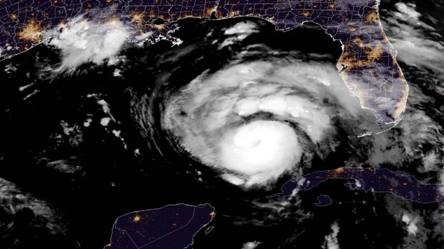
Hurricane Ida is 285 miles southeast of Louisiana, will strengthen to category 4 in next 12-18 hours
Hurricane Louisiana was about 285 miles from the coast of Louisiana as of 8 p.m. ET, moving northwest across the Gulf of Mexico at 16 mph, according to the National Hurricane Center's latest advisory.
Maximum sustained winds were 105 mph at 8 p.m., but rapid strengthening is forecast over the next 12 to 18 hours that is projected to turn the storm into a category 4 hurricane.
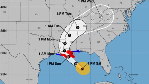
Gov. Jon Bel Edwards said the coast of Louisiana will start experiencing tropical storm force winds around 8:00 a.m. CT on Sunday.
"This will be one of the strongest storms to hit Louisiana since at least the 1850s. We can also tell you that your window of time is closing. It is rapidly closing," Gov. Edwards said Saturday afternoon. "By the time you go to bed tonight you need to be where you intend to ride this storm out, and you need to be as prepared as you can be."
"Hurricane Hunter" aircraft passes through eye of Ida, confirms the storm is intensifying
A research plane known as the "Hurricane Hunter" passed through the eye of Ida shortly before 6 p.m. ET on Saturday, according to NOAA's Cooperative Institute for Meteorological Satellite Studies.
There were no surprises on the flight, but it did confirm that the storm continues to strengthen ahead of landfall on Sunday.

The NOAA has two Lockheed WP-3D Orion aircrafts that use a blend of scientific instruments and radar systems to get a better read on storms.
"To obtain the best possible data within the storm environment, crewmembers deploy expendable probes called GPS dropwindsondes through a launch tube in the aircraft," the NOAA explains. "As they parachute to the sea below, the probes transmit pressure, temperature, humidity, wind speed and wind direction data back to the aircraft."
Hurricane IDA is expected to strengthen to a category 4 hurricane in the next 10-16 hours. It was roughly 300 miles southeast of the coast of Louisiana around 7:30 p.m. ET.
Animal shelters around the country taking in pets from Louisiana
Pets in animal shelters around Louisiana are finding new homes as humane societies take in hundreds of animals that are in the path of Hurricane Ida.
The Houston Society for the Prevention of Cruelty to Animals took in 150 cats and dogs on Saturday who were in harm's way.
The Jacksonville Humane Society put out a call Saturday for fosters and adopters to take in pets on their way from Louisiana to Florida, saying that adoption fees would be waived.
Even as far away as Brandywine Valley, Pennsylvania, groups are working to find a new home for pets from Louisiana.
The Brandywine Valley SPCA welcomed 110 dogs and cats Saturday, mostly from the Tangipahoa Parish animal shelter in southeast Louisiana.
President Biden is briefed by FEMA, urges Americans in Hurricane Ida's path to prepare
President Biden was briefed by FEMA Saturday on emergency preparations for Hurricane Ida, which is expected to become a category 4 hurricane by the time it makes landfall in Louisiana Sunday.
The President urged Americans in harm's way to prepare for the storm and said FEMA has "deployed emergency response personnel and pre-positioned food, water, generators, and supplies."
On Friday, Biden met with Alabama Gov. Kay Ivey, Louisiana Gov. John Bel Edwards and Mississippi Gov. Tate Reeves about preparations for the storm.
FEMA has established a base in Alexandria, Louisiana, about 200 miles northwest of New Orleans, where they have 13 search and rescue teams on standby, a U.S. Army Corps of Engineers power restoration team, fifty ambulances, one million meals, 1.6 million liters of water, and 90 generators.
“Anyone in the forecast path should complete final preparations as soon as possible, monitor their local news for updates and directions provided by their local officials, and heed local evacuation orders,” FEMA Administrator Deanne Criswell said Saturday. “This is going to be a major hurricane. Please be safe and listen to local emergency management officials.”
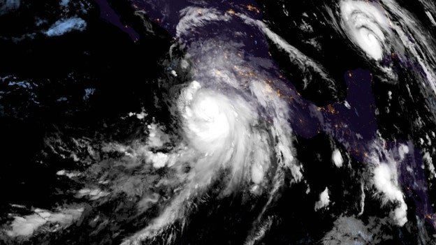
NASA Astronaut posts pictures of Hurricane Ida from space
NASA Astronaut Megan McArthur captured images of Hurricane Ida from the International Space Station on Saturday as it gains strength in the Gulf of Mexico.
The pictures, taken around 1 p.m. ET, show the storm about 350 miles southeast of Houma, Louisiana.
Ida is currently a category 2 hurricane but is expected to go through a period of rapid strengthening and become a category 4 hurricane over the next 12 hours.
Louisiana expected to get 8-16 inches of rain with isolated maximum amounts of 20 inches
Hurricane Ida, which is expected to strengthen to a category 4 hurricane over the next 12-18 hours, is projected to bring 8 to 16 inches of rain to the gulf coast when it makes landfall Sunday.
Heavy rainfall will first hit the Louisiana coast early Sunday morning, then spread northeast into the Lower Mississippi Valley on Sunday evening into Monday.
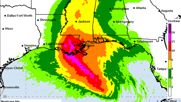
According to the latest forecast from the National Oceanic and Atmospheric Administration, parts of metropolitan New Orleans could get as much as 20 inches of rain.
To the east, Mobile is expected to get 6 to 10 inches of rain, while to the west, Lafayette could get 4 to 6 inches.
"Elsewhere across eastern Louisiana, Mississippi, far southwestern Alabama and the Middle Tennessee Valley -- considerable flash and riverine flooding impacts are likely on Monday and Tuesday, with rainfall totals of 4 to 8 inches possible," the National Hurricane Center said in an advisory Saturday afternoon.
Louisiana National Guard preparing for Hurricane Ida
The Louisiana National Guard is working with the Governor's Office of Homeland Security and Emergency Preparedness to prepare for Hurricane Ida.
Guardsmen are staging boats, highwater vehicles, and other assets, as well as gathering across Louisiana, as well as gathering ready to eat meals, water, and supersacks of sand.
Miami-Dade Fire Rescue sending search and rescue team to Alabama ahead of Hurricane Ida
Miami-Dade Fire Rescue is deploying a 45-member search and rescue team and two canines to Alabama in preparation for a rapid response to Hurricane Ida.
The team specializes in a dozen areas, including technical search, advanced medical care, hazardous materials mitigation, and logistics support.
“We are always ready to respond to any type of incident when our resources and expertise are needed," Fire Chief Alan Cominsky said ahead of the deployment. "We continuously train to be prepared for any type of disaster.”
A 2-member team was also already deployed as part of FEMA's initial efforts to prepare for the storm.
Hurricane Ida is 325 miles from Louisiana, will reach category 4 status in 12-18 hours
Hurricane Ida was about 325 miles southeast of Houma, Louisiana at 5 p.m. ET on Saturday, moving northwest at 16 mph, according to the National Hurricane Center.
Maximum sustained winds are around 105 mph but could strengthen to as high as 140 mph by the time Ida makes landfall along the Louisiana coast on Sunday.
Life-threatening storm surge inundation is threatening the coasts of Louisiana, Mississippi, and the southwest part of Alabama.
New Orleans and other areas along Louisiana's coast could face "potentially catastrophic wind damage" when the core of the hurricane moves onshore.
Heavy rainfall is expected Sunday and Monday across southeast Louisiana, coastal Mississippi, and far southwestern Alabama. Flooding is possible in Lower Mississippi, Tennessee, and Ohio Valleys early next week as the hurricane moves inland.
Louisiana Gov says Hurricane Ida will be "one of the strongest storms to hit Louisiana since" 1850s

Louisiana Gov. Jon Bel Edwards told the public to evacuate if they need to and spend the next 24 hours preparing before Ida makes landfall Sunday, calling the hurricane "one of the strongest storms to hit Louisiana since at least the 1850s."
"I know that tomorrow, for many people, is a very difficult anniversary. It is the 16th anniversary of Hurricane Katrina. I'm also aware that it is very painful to think about another powerful storm like Hurricane Ida making landfall on that anniversary," Gov. Bel Edwards said at a press conference on Saturday afternoon.
"Every storm is different. They all bring their own challenges, but I also want you to know that we’re not the same state we were 16 years ago."
The Governor noted that "many, many people are heeding the evacuation orders, both mandatory and voluntary."
Hurricane Ida is currently a category 2 hurricane several hundred miles southeast of New Orleans, but is projected to rapidly strengthen as it gets closer to the coast.
The storm is expected to bring up to 140 mph winds, 8-16 inches of rain, storm surge up to 10-15 feet, and other dangerous conditions to the Gulf Coast.
Almost all gulf oil production "shut in" as Hurricane Ida makes its way to New Orleans
Oil and gas wells at the bottom of the ocean have been "shut in" and half of all offshore oil and gas production platforms in the Gulf of Mexico have been evacuated as Hurricane Ida makes its way toward Louisiana.
"This involves closing the sub-surface safety valves located below the surface of the ocean floor to prevent the release of oil or gas," the Bureau of Safety and Environmental Enforcement said in a statement. "Shutting in oil and gas production is a standard procedure conducted by industry for safety and environmental reasons."
Half of all offshore oil and gas production platforms, 279 of 560, were evacuated as of Saturday.
Click here to read more on Fox Business.
Alabama Governor declares state of emergency ahead of Hurricane Ida
Alabama Gov. Kay Ivey declared a state of emergency for the state's coastal and western counties on Saturday afternoon ahead of Hurricane Ida.
"We will continue keeping an eye on the evolving system," the Governor said in a statement. "I urge Alabamians and our visitors to stay weather aware."
Hurricane Ida is aimed directly at New Orleans, about 130 miles west of Alabama, but the state will still see rain, wind, and even possibly tornados in central and southern Alabama when the storm makes landfall Sunday.
A storm surge watch is also currently in effect for Mobile Bay in the southwest corner of Alabama.
President Biden is briefed on Hurricane Ida: 'Pay attention and be prepared'

In a briefing with FEMA (Federal Emergency Management Agency) officials, President Joe Biden urged those impacted by Hurricane Ida to make preparations.
"This weekend is the anniversary of Hurricane Katrina and it's a stark reminder that we have to do everything we can to prepare the people in the region and make sure we're ready to respond," the president said.
Biden said he and FEMA Administrator Deanne Criswell had spoken to the governors of Louisiana and Alabama ahead of the storm, noting that he had already signed an emergency declaration for Louisiana.
The president pointed out that 500 FEMA emergency response personnel were deployed in Texas and the Bayou State in addition to 2,000 FEMA personnel already supporting COVID-19 pandemic response in the region.
Additionally, Biden said, the government has positioned food, water, generators and other resources in the area.
Power restoration and mobile communication support teams are "en route," he said.
"We've also closely coordinated with the electric utilities to restore power as soon as possible and support your response and recovery efforts," Biden noted.
"And above all, I'm urging the people of the area to pay attention and be prepared," the president stated. "I want to say it again, pay attention to be prepared, have supplies for your household on hand, follow the guidance from local authorities. And, if you have to move to shelter, make sure you wear a mask and try to keep some distance because we're still facing a highly contagious Delta variant as well."
New Orleans mayor addresses residents on Hurricane Ida: 'This is it'

Speaking to reporters in a news conference on Saturday, New Orleans Mayor LaToya Cantrell urged residents to voluntarily evacuate now.
"Everyone has to make a decision. To leave voluntarily, which I'm recommending -- do that. Prepare yourselves. If you're going to leave, you need to do that now," she said. "We need to make sure that you are in a safe place: everyone. Whether you're going to leave voluntarily or stay on site, hunker down, wherever that is."
While a combination of voluntary and mandatory evacuations have been called for cities and communities across the region and the mayor had ordered a mandatory evacuation for areas outside the city’s levee system and a voluntary evacuation for residents inside the levee system, Cantrell said it was not possible to order a mandatory evacuation for the entire city.
She warned that Hurricane Ida would bring damaging wind, power outages, heavy rain and tornadoes.
"What I'm told is that this storm in no way will be weakening," she said, adding that time is not on the city's side.
"And so...if you are voluntarily evacuating our city, now is the time to leave. You need to do so immediately," said Cantrell.
Those who are riding out the storm, the mayor said, should have supplies in hand. The city was focusing specifically on a post-storm response due to the time of the hurricane, which is expected to make landfall on the northern Gulf Coast on Sunday.
Even as the National Hurricane Center warned that the overtopping of local levees outside of the Hurricane and Storm Damage Risk Reduction System is possible, Cantrell said she is "very confident" in New Orleans' levee protection system.
That said, she highlighted the impact of the ongoing COVID-19 pandemic during hurricane season.
"We're in the midst of a pandemic. Our assets have been compromised in terms of meeting the needs. Our hospitals are at capacities as well," Cantrell said. "So, the best thing that our people can do is to evacuate and they need to be in their place that they're evacuating to by midnight tonight."
FEMA urges Gulf Coast preparedness 'now'
In a Saturday release, the Federal Emergency Management Agency (FEMA) urged those impacted by Hurricane Ida to "take urgent steps now" before it is forecast to make landfall on Sunday as a dangerous major hurricane.
“Anyone in the forecast path should complete final preparations as soon as possible, monitor their local news for updates and directions provided by their local officials, and heed local evacuation orders,” FEMA Administrator Deanne Criswell said. “This is going to be a major hurricane. Please be safe and listen to local emergency management officials.”
The agency noted that severe weather threats associated with the storm include life-threating storm surge, dangerous hurricane-force winds, extreme rainfall and the possibility of a few tornadoes.
FEMA also said that President Joe Biden's approval of Louisiana’s request for an emergency declaration authorizes FEMA to coordinate all disaster relief efforts and "provide appropriate assistance for required emergency measures to save lives and to protect property and public health and safety in all 64 Louisiana parishes."
The agency noted that it has deployed more than 2,000 employees to Alabama, Florida, Georgia, Louisiana, Mississippi and Texas and has four FEMA Incident Management Assistance Teams in Louisiana, two in Mississippi and one on standby.
FEMA has established an Incident Support Base in Alexandria, La. and there are 50 ambulances and emergency medical service providers and a U.S. Army Corps of Engineers Power Restoration team ready to deploy post-storm.
One million meals, 1.6 million liters of water and 90 generators are also being pre-positioned to rapidly deploy.
FEMA instructs that residents prepare now, monitoring the latest news and evacuating if told to do so.
People in affected areas should gather supplies including medication, disinfectant supplies, face masks, pet supplies and a battery-operated radio with extra batteries.
Generators -- often used during outages -- should never be used inside a home, basement, shed or garage even if doors and windows are open, FEMA said.
Residents are warned to never drive through flood waters, as almost half of all flash flood deaths happen in vehicles, and stay out of floodwaters.
It's also important to monitor where floodwaters have receded, as roads may have weakened.
Residents are asked to keep refrigerator and freezer doors closed and use only flashlights or battery-powered lanterns for emergency lighting.
Lastly, FEMA asks that people check on neighbors who may require assistance, if it is safe to do so.
Officials warn residents as New Orleans braces for Hurricane Ida

In the "Big Easy," traffic was heavy on westbound routes out of town and gas stations were bustling.
“Today is it,” Jamie Rhome, acting deputy director of the U.S. National Hurricane Center in Miami, said Saturday. “If you’re in coastal Louisiana and Mississippi, you really, really have to get going because today is it in terms of protecting life and property.”
The city was scrambling to prepare ahead of Hurricane Ida, which is expected to make landfall on Sunday as a Category 4 hurricane.
Collin Arnold, the city’s emergency management director, said the city could be under high winds for about 10 hours.
Other threats include flooding in normally dry near the coast due to a combination of the tide and dangerous storm surge, heavy rainfall and even tornadoes.
“We want to be clear, that with the amount of rain now forecasted, approximately 10 inches over the course of the event, it is likely that we will experience flooding,” the city said in a Friday statement.
Some New Orleans businesses closed their doors on Saturday and other lined doors with sandbags to protect against flash floods.
The hurricane center also cautioned that storm surge could overtop some levees.
Heath Jones, emergency manager of the Army Corps of Engineers’ New Orleans District, said levees that protect parts of New Orleans on the west bank of the Mississippi River are designed to be overtopped -- with safeguards in place to prevent additional damage.
He said that there does not appear to be any danger of storm surge coming over the levees guarding the city's east bank.
The Associated Press contributed to this report.
Hurricane Ida is expected to begin 'rapidly intensifying' soon

The National Hurricane Center warned late Saturday morning that Hurricane Ida was expected to begin "rapidly intensifying" soon as the storm moves over the Gulf of Mexico about 435 southeast of Houma, Louisiana.
The Category 1 hurricane had maximum sustained winds near 85 mph with higher gusts and hurricane winds extend outward up to 30 miles from the center.
Tropical-storm-force winds extend outward up to 125 miles, according to the hurricane center.
"Rapid strengthening is forecast during the next 24 to 36 hours and Ida is expected to be an extremely dangerous major hurricane when it approaches the northern Gulf coast on Sunday," the agency wrote in a Facebook post.
Ida is projected to make landfall along the U.S. northern Gulf Coast on Sunday and shift inland over parts of Louisiana or western Mississippi later on Monday.
Heavy rainfall and flooding -- including "life-threatening flash and urban flooding and significant river flooding impacts" -- from the combination of dangerous storm surge and the tide are anticipated and the hurricane center warned of the possibility of tornadoes from Sunday into Monday across parts of eastern Louisiana, Mississippi, central and southern Alabama and the Florida Panhandle.
"The longest duration tornado threat will exist across southeast Louisiana and southern Mississippi," the hurricane center noted.
As Hurricane Ida moves rapidly toward Gulf Coast, Nora could impact Southwest
As Hurricane Ida moves rapidly toward Gulf Coast, Hurricane Nora was swirling over the eastern Pacific Ocean on Saturday.
According to the National Hurricane Center, the storm was located approximately 230 miles south of Cabo Corrientes, Mexico and moving toward the northwest near 12 mph.
The center of the storm is expected to reach the southwestern coast of Mexico later Saturday before passing near the coast of the states of Jalisco and Nayarit.
The Category 1 hurricane is then projected to move into the Gulf of California on Sunday and Monday.Heavy rain associated with Nora will fall across coastal portions of the Mexican states of Guerrero, Michoacan, Colima and Jalisco.
Rainfall totals of 8 to 12 inches are forecast through the weekend with the potential for isolated maximum amounts of 20 inches, producing life-threatening flash flooding and mudslides.
As Nora moves north-northwest, the rainfall will shift into the Baja California Sur late Sunday into Monday.
For portions of Baja California Sur, rainfall totals of 4 to 8 inches are forecast, with isolated maximum amounts of 12 inches.
Life-threatening flash flooding and mudslides may also occur there as a result. Additional storm-term strengthening is anticipated as long as Nora remains offshore of the Mexican coastline.
On Saturday, AccuWeather meteorologists were reportedly monitoring the potential for flooding and "tropical downpours" in the southwestern U.S.
While the storm may no longer be designated a hurricane or even a tropical storm by the time it reaches the area, AccuWeather Senior Meteorologist Rob Miller said that Nora could still "bring a dose of tropical moisture to parts of Arizona, Utah, New Mexico and Colorado that could lead to flash flooding during the middle and end of next week."
Louisianans take one last day to prepare for Hurricane Ida

As Hurricane Ida moves northwest still hundreds of miles southeast of New Orleans, Louisianans were taking one final day to prepare for what is being described as a "life-altering" storm.
With some mandatory and voluntary evacuations in order, Mayor LaToya Cantrell told New Orleans residents that they should get ready to ride out the storm as there was not enough time to establish the procedures needed to move all residents out of the city before the storm's expected landfall on Sunday.
"We are not calling for a mandatory evacuation because the time simply is not on our side. We do not want to have people on the road, and therefore in greater danger,” Cantrell said, according to NOLA.com.
Cantrell noted that the situation had increased in severity.
Ida is expected to make landfall as a Category 4 hurricane on Sunday when it strikes the Gulf Coast, with maximum winds of 140 mph.
The storm is expected to make landfall on the exact date that Hurricane Katrina devastated the region 16 years prior.
New Orleans officials warned residents to be prepared for prolonged power outages and KPVI reported that New Orleans utilities Entergy, SWEPCO and Cleco said Friday they were bringing in thousands of extra linemen.
Meanwhile, people were filling sandbags, stocking up on groceries and getting gas for cars and generators.
President Joe Biden approved a federal emergency declaration for Louisiana ahead of the hurricane and White House press secretary Jen Psaki said FEMA plans to send nearly 150 medical personnel and almost 50 ambulances to the Gulf Coast.
The Associated Press contributed to this report.
National Hurricane Center: Hurricane Ida preparations in Gulf Coast should be completed today
The National Hurricane Center urged residents in impacted areas to prepare on Saturday ahead of Hurricane Ida.
Hurricane conditions, the agency said, are expected in the hurricane warning area along the northern Gulf Coast beginning on Sunday, with tropical storm conditions projected to begin by late Saturday night or early Sunday morning.
"These conditions will spread inland over portions of Louisiana and Mississippi Sunday night and Monday. Preparations to protect life and property should be rushed to completion," the center said in an update on Facebook.
At 7 a.m. CT, the Category 1 hurricane was located approximately 440 miles southeast of New Orleans, La.
The storm's center is forecast to move over the southeastern Gulf of Mexico and into the central Gulf of Mexico before making landfall over the U.S. northern Gulf Coast and moving inland over portions of Louisiana or western Mississippi later on Monday.
The storm is expected to strike the region as a Category 4 hurricane, with maximum winds of 140 mph. The hurricane will weaken after making landfall.
The hurricane center also warned of life-threatening flooding and storm surge from 10 to 15 feet above group from Morgan City, La. to the Mouth of the Mississippi River.
Total rainfall accumulations of 8 to 16 inches with isolated maximum totals of 20 inches are possible across southeastern Louisiana and southern Mississippi through Monday.
“This will be a life-altering storm for those who aren’t prepared,” National Weather Service meteorologist Benjamin Schott told reporters during a Friday news conference with Louisiana Gov. John Bel Edwards.
The Associated Press contributed to this report.
Hurricane and tropical storm conditions are ending over Cuba
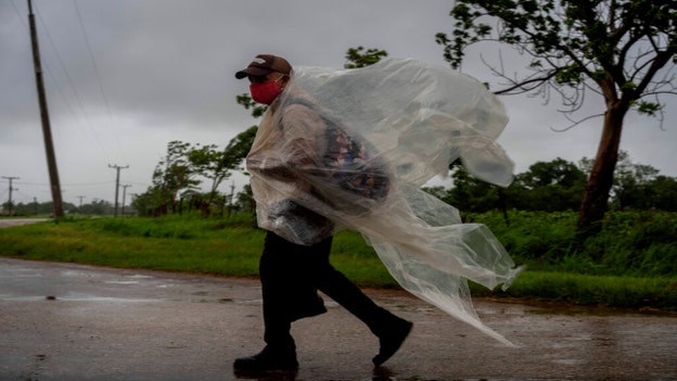
While tropical storm and hurricane conditions brought by Hurricane Ida are ending over Cuba this morning, the storm is expected to continue to bring periods of heavy rainfall that may lead to dangerous flash flooding and mudslides.
In an update, the National Hurricane Center warned of life-threatening storm surge inundation from Ida on Sunday for the coasts of both Louisiana and Mississippi within warning areas.
Surge from 10 to 15 feet above ground is possible from Morgan City, La. to the Mouth of the Mississippi River.
Additionally, Hurricane Ida -- now a Category 1 hurricane -- is expected to strengthen into a Category 4 storm being making landfall in Louisiana late Sunday.
Hurricane-force-winds are expected Sunday in portions of the Hurricane Warning area along the Louisiana coast with "potentially catastrophic wind damage possible where the core of Ida moves onshore."
The agency said that Ida is likely to produce heavy rainfall later on Sunday and into Monday across the central Gulf Coast, resulting in significant flash and riverine flooding impacts.
There is also the potential for flooding impacts across parts of the Lower Mississippi and Tennessee Valleys as the hurricane moves inland.
Ida expected to hit Louisiana on the same date Katrina devastated the area 16 years earlier
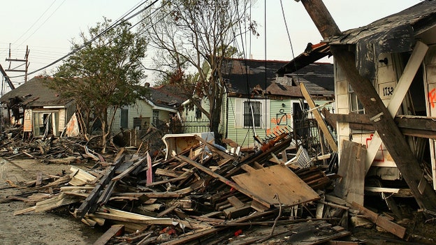
Hurricane Ida is expected to make landfall over Louisiana on Sunday, Aug. 29, potentially as a Category 4 Hurricane that officials said could be "life-altering" if residents don't take the proper precautions.
Katrina is blamed for an estimated 1,800 deaths from the central Louisiana coast to around the Mississippi-Alabama state line. A massive storm surge scoured the shores and wiped houses off the map. In New Orleans, failures of federal levees led to catastrophic flooding. Water covered 80% of the city and many homes were swamped to the rooftops. Some victims drowned in their attics. The Superdome and New Orleans Convention Center became scenes of sweltering misery as tens of thousands were stranded without power or running water.
Katrina still haunts the city, which has never fully recovered from its savagery.
New Orleans evacuates as Hurricane Ida expected to strengthen to Category 4 with 140 mph winds
Mandatory evacuations were being ordered in Louisiana on Friday as Ida gains strength in the gulf.
The center of Ida was located over western Cuba around 8 p.m. ET on Friday. Jamaica, the Cayman Islands, and western Cuba faced heavy rains, flash flooding, and mudslides throughout Friday evening.
Click here to read more on Fox News
Saints-Cardinals preseason game canceled as Hurricane Ida churns toward Gulf Coast
The New Orleans Saints and Arizona Cardinals on Friday canceled their third and final preseason game slated for this weekend, as New Orleans braces for another major storm, 16 years after Hurricane Katrina.
"At the request of Louisiana Gov. John Bel Edwards, the NFL and the New Orleans Saints announced Friday, Aug. 27 that due to the impending impact of Hurricane Ida on the Gulf Coast region that the team's preseason game against the Arizona Cardinals has been canceled," a statement on the Saints’ website read.
Click here to read more on Fox News
Ida moving into the Gulf of Mexico
Hurricane Ida is moving into the Gulf of Mexico and there is a danger of a life-threatening storm surge inundation -- 10 to 15 feet above ground level is possible -- along parts of the coast of Mississippi and Louisiana on Sunday.
Live Coverage begins here