


Winter is about to make a fierce return in parts of the country that have not seen much snow so far this season, with a pair of storms -- including a "blockbuster" -- set to bring more than a foot of fresh powder by the time the weekend is over.
The National Weather Service's Weather Prediction Center said Thursday that "freezing rain, heavy snow, and heavy rain" associated with a storm over the Western U.S. will move through the Midwest and Northeast over the next few days.
"Heavy snow will begin by Friday evening over the central plains and then progress eastward by the weekend," the NWS said.
HEAVY SNOW FORECAST FOR NORTHEAST THIS WEEKEND; WEST REMAINS ACTIVE
Light snow is forecast to fall in portions of the Mid-Atlantic and Northeast from Thursday into Friday, but it's the second system that has the attention of forecasters.

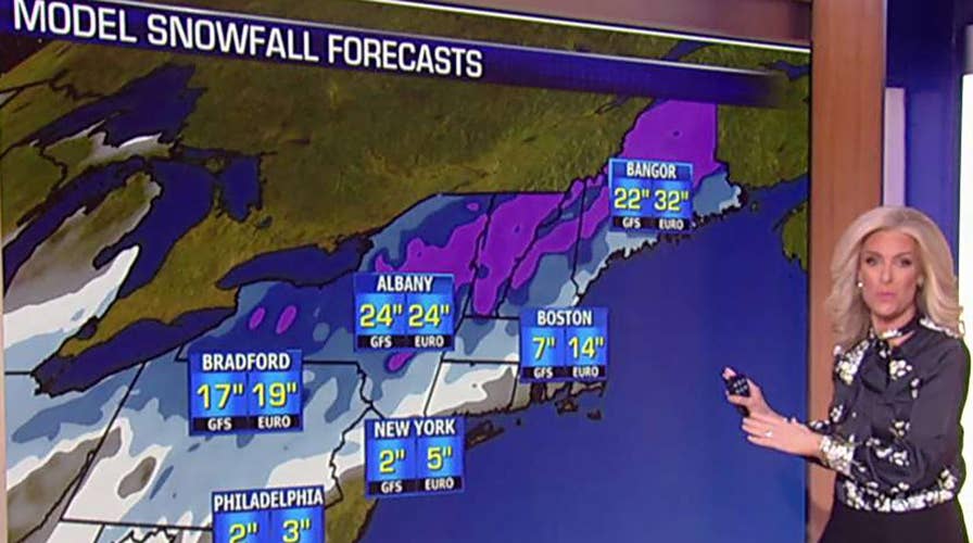
Preliminary snowfall totals from a major winter storm to target the Northeast on Sunday.
"Of greater concern is the next system this coming weekend, which will be much stronger with heavier precipitation," Fox News Senior Meteorologist Janice Dean said Thursday.
Double Trouble

A weaker system is expected to bring light snow into the Northeast from Thursday night into Friday. (Fox News)
The first, weaker storm will move through the Midwest into the Northeast from Thursday into Friday, giving the region its first shot of winter weather.
"A relatively weak system will bring rain and snow to the Mid-Mississippi River Valley and Ohio River Valley today, then light snow to portions of the Mid-Atlantic and Northeast late tonight into Friday morning," Dean said.
The National Weather Service said between 1 to 2 inches of snow can be expected in the major Northeast cities, while between 3 and 6 inches of snow could fall in high elevation areas.
"Light snowfall is expected, but impacts to Thursday evening and Friday morning commutes are possible," the NWS' Mount Holly office said. "A brief respite before another significant storm system impacts our area into the weekend."
Major storm to impact weekend travel in Midwest, Northeast
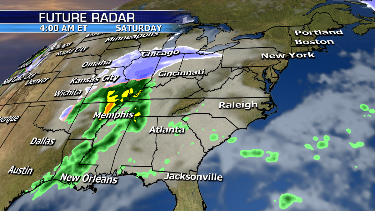
The storm will impact the Midwest on Saturday before targeting the Northeast.
The second storm, dubbed a "blockbuster" by AccuWeather, is expected to impact the Midwest on Saturday before targeting the Northeast.
"The highest confidence for the heaviest snow Saturday morning through Sunday remains from the interior Northeast and interior New England, where over a foot is possible," Dean said.
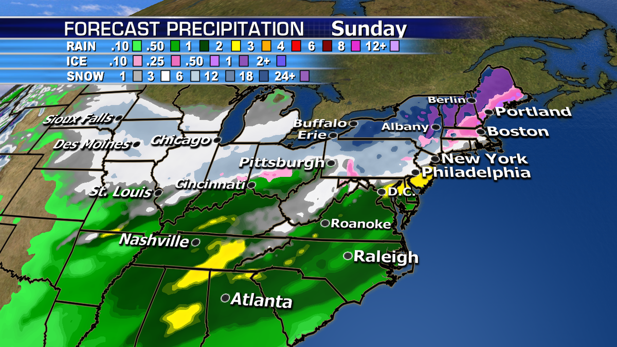
The forecast precipitation from the weekend storm in the Midwest and Northeast.
A mix of snow, ice/sleet, and rain are expected in the Interstate 95 corridor from New York City and southward is expected on Sunday before changing back to snow, according to Dean.
Boston and areas north of the city will most likely see more snow than the rest of the I-95 corridor.

CLICK HERE FOR THE FOX NEWS APP
The onset of the wintery precipitation will arrive by Saturday night and end by Sunday afternoon for most people, according to Dean.
But once the wintry precipitation ends, don't expect it to melt away anytime soon.
"Behind all this snow, rain, and wintry mix, an Arctic air mass will rush across the Great Lakes and Midwest Sunday, then the Northeast Sunday night into Monday, bringing frigid temperatures and even colder wind chills," Dean said
The NWS said that "bitterly cold air" with wind chills well below zero degrees will linger through Tuesday, and extended amount of cold temperatures sticking around through the end of the month.

True Crime
The hottest stories ripped from the headlines, from crime to courts, legal and scandal.
By entering your email and clicking the Subscribe button, you agree to the Fox News Privacy Policy and Terms of Use, and agree to receive content and promotional communications from Fox News. You understand that you can opt-out at any time.
