


Fox News Flash top headlines for January 15
Fox News Flash top headlines are here. Check out what's clicking on Foxnews.com.
Millions of Americans are in the path of a strong winter storm, which began to impact the Midwest on Friday.
Heavy snow in the region led to school closures or altered instruction and to the deterioration of travel conditions.
Southwest Airlines warned of possible flight cancellations, diversions and delays on Friday and Saturday at airports in St. Louis, the Twin Cities, Kansas City, Missouri, Des Moines and Omaha.
The National Weather Service (NWS) issued a winter storm warning for parts of Minnesota, the Dakotas, Iowa and Illinois, where forecasters were expecting up to 10 inches.
Motorists reported roads on Interstate 94 in North Dakota had packed ice and snow.
The storm system is expected to track through the Mid-Mississippi Valley into the Southeast and then up the Eastern Seaboard by Monday.
In South Carolina, shoppers scoured storm shelves for storm supplies and Gov. Henry McMaster issued an emergency order.

Hoes used to fill brine are seen near brine tank storage bins ahead of a winter storm at the GDOT’s Maintenance Activities Unit location on Friday, Jan. 14, 2022, in Forest Park, Ga. A winter storm is headed south that could effect much of Georgia thru Sunday. (AP Photo/Brynn Anderson)
"South Carolina will be impacted by a major winter storm this weekend, likely beginning Sunday morning," the governor said in a statement. "There is a potential for very dangerous conditions caused by accumulations of ice and snow, which will likely result in power outages across the state. I urge South Carolinians to monitor their local weather forecasts and begin taking safety precautions. We will hold a media briefing tomorrow afternoon to update residents with the latest information on this winter storm."
The NWS said from 2 to 5 inches of snow could fall as far as northeastern Georgia from Saturday night from Sunday, with ice and winds gusting to 35 mph exacerbating the threat of power outages and precarious travel conditions. Snow accumulations could reach up to 8 inches in the highest elevations.
Winter storm watches were posted for Saturday in Georgia, South Carolina and Mississippi.
Georgia Gov. Brian Kemp, who also declared a state of emergency late Friday, said the state was preparing "to the max."
Parts of Tennessee could see as much as 6 inches of snow and northern Mississippi and the Tennessee Valley region of Alabama could receive light snow accumulations.
BETTY WHITE-OUT? MICHIGAN NAMES SNOWPLOW AFTER LEGENDARY ACTRESS
North Carolina Gov. Roy Cooper signed a state of emergency on Friday and the administration urged people to stay at home after the storm hits.
"This storm will bring significant impacts from snow, sleet and freezing rain in different parts of the state, with likely power outages and travel disruptions," he said in a statement. "North Carolinians should pay close attention to their local weather forecast over the next few days, and make sure they are personally prepared before Saturday afternoon."
The North Carolina Department of Transportation warned that labor shortages meant crews might not respond to problems areas as quickly as normal.
Farther to the North, Virginia Gov. Ralph Northam declared a state of emergency, calling on residents to take the storm seriously.
Virginia State Police warned people to avoid travel over the weekend – just days after a previous blizzard left thousands of motorists trapped on part of Interstate 95.
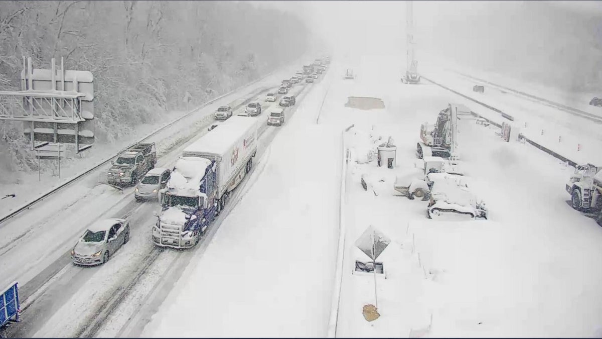
This image provided by the Virginia department of Transportation shows a closed section of Interstate 95 near Fredericksburg, Va., on Monday. (Virginia Department of Transportation/AP)
The storm will likely bring snow, sleet, ice and freezing rain to much of the state and up to a foot of snow is predicted in parts of southwestern Virginia.
The Virginia National Guard alerted personnel Friday for possible storm response and planned to stage 60 soldiers along the Interstate 81 and Route 460 corridors.
To the Northeast, bitterly cold weather settled ahead of the storm.
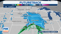
The NWS said the storm will move from the Southeast to the northern Mid-Atlantic, with pockets of rain and freezing rain developing over the region and southern Appalachians overnight on Saturday.
CLICK HERE TO GET THE FOX NEWS APP
On Sunday, the agency wrote that heavy snow will develop over parts of the central and southern Appalachians and Mid-Atlantic, as well as "significant areas" of rain and freezing rain.
Snow is forecast to move into parts of the lower Great Lakes and Ohio Valley, with rain and freezing rain shifting into the northern Mid-Atlantic.
"Meanwhile, a boundary over central Canada will move into the upper Midwest by Sunday. The system will produce light snow over parts of the upper Mississippi Valley and the upper Great Lakes for Sunday and begin to wane by Monday morning. The snow will result in reduced visibility and hazardous driving conditions," the NWS added.
The Associated Press contributed to this report.

True Crime
The hottest stories ripped from the headlines, from crime to courts, legal and scandal.
By entering your email and clicking the Subscribe button, you agree to the Fox News Privacy Policy and Terms of Use, and agree to receive content and promotional communications from Fox News. You understand that you can opt-out at any time.
