


Tropical Storm Barry brings major risk of flooding to the Gulf Coast
Rob Schmitt gives you the latest updates on Tropical Storm Barry from Mandeville, Louisiana. Rick Reichmuth tracks the storm.
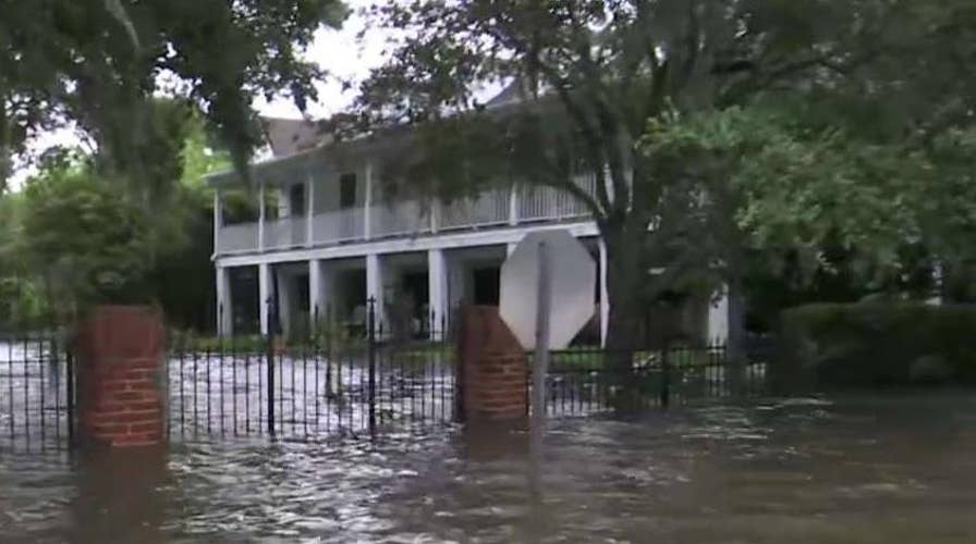
After making landfall in Louisiana, Tropical Storm Barry continued making its slow trek northward on Sunday across the region, bringing the threat of flash flooding for the lower Mississippi River valley and warnings by officials to stay out of the water due to what may lurk underneath.
The National Hurricane Center said as of 11 a.m. ET that Barry was located about 80 miles south-southeast of Shreveport, moving north at 6 mph with sustained winds of 40 mph. After briefly becoming a Category 1 hurricane on Saturday, the system weakened to a tropical storm, the NHC said.
"Across the remainder of the Lower Mississippi Valley, total rain accumulations of 4 to 8 inches are expected, with isolated maximum amounts of 12 inches," the NHC said. "This rainfall is expected to lead to dangerous, life-threatening flooding."
In Mississippi, up to 3 inches of rain had already fallen in the Jackson area before dawn Sunday — and more was on the way. That prompted the National Weather Service to issue a flash flood warning for the captial city of Jackson and some of its suburbs.
TROPICAL STORM BARRY: 3 HURRICANE MYTHS DEBUNKED
President Trump took to Twitter to warn people across the region to be on guard as the day went on.
"A big risk of major flooding in large parts of Louisiana and all across the Gulf Coast," the president tweeted. "Please be very careful!"
First responders across the region echoed the president’s sentiments and urged people to stay out of floodwaters for a different reason: other creatures that may lurk below.
The St. Tammany Fire Prevention District #1 posted pictures to Facebook on Saturday of several snakes that fire crews have come across in Slidell, La.

Several snakes that fire crews have come across in floodwaters from Tropical Storm Barry. (St. Tammany Fire Prevention District #1)
"If the area you live in has high water, watch out for snakes and other critters who are trying to escape the floodwaters as well," the agency said.
BARRY MAKES LANDFALL IN LOUISIANA AFTER WEAKENING BACK TO TROPICAL STORM
In Livingston Parish, a family and a dog had a very close encounter with an alligator. The Louisiana Governor’s Office of Homeland Security and Emergency Preparedness posted a video to its Twitter account of the close encounter.
"No animals were harmed while this video was recorded," the agency said.
Late Saturday night, authorities were trying to rescue a family of five who were trapped by high water in the south Louisiana town of Franklin, according to KTBS-TV. The National Guard had to halt its initial rescue mission because waters were too high to safely reach the family's home. Franklin is about 40 miles southeast of Lafayette.
When officials eventually got to the home, the people living there said they didn't need to be rescued, officials told the television station.

As the Atchafalaya River continues to rise due to the rains of Tropical Storm Barry, it becomes harder to see the Morgan City name on the sea wall, Saturday, July 13, 2019, in Morgan City, La. (AP Photo/Rogelio V. Solis)
"We got to a spot where we were starting to float a little bit and I wasn't comfortable with that so we stopped a bit," Bossier Parish Sheriff's Office Dep. Steve Dooley told KTBS. "We didn't have very far to go so we decided to drive the rest of the way. We made it to the house, and they just didn't want to come out."
The deputies told KTBS that floodwaters in the area dropped significantly throughout the evening.
TROPICAL STORM BARRY: SAFETY TIPS FOR PETS
The storm's first wave had not inundated New Orleans as feared, with the city experiencing moderate rain Saturday. Forecasters downgraded rainfall estimates for the city through Sunday to between 2 to 4 inches. Earlier forecasts of quadruple that amount had raised concerns that water pumps strengthened after Hurricane Katrina would be overwhelmed.
Tropical Storm Barry drenches southern Louisiana
FEMA acting administrator Pete Gaynor says his top priority is life safety.
None of the main levees on the Mississippi River failed or were breached, and they were expected to hold up through the storm, Gov. John Bel Edwards said. But a levee in Terrebonne Parish was overtopped by water for part of the day, officials said. Video also showed water getting over a second levee in Plaquemines Parish, where fingers of land extend deep into the Gulf of Mexico.
“The levees did do really well along the Mississippi River but there's all those others rivers, it's a very wet area, there's a lot of moisture there, a lot of rivers that are going to continue to rise. so we have a long ways to go with this,” Fox News Chief Meteorologist Rick Reichmuth said on “FOX & friends.”
CLICK HERE FOR THE FOX NEWS APP
In other parts of Louisiana on Saturday, Barry flooded highways, forced people to scramble to rooftops and dumped heavy rain as it made landfall near Intracoastal City, about 160 miles west of New Orleans. Downpours also lashed coastal Alabama and Mississippi.

This photo shows the Gulf Intracoastal Waterway West Closure Complex, Saturday, July 13, 2019 in Belle Chasse, La. (AP Photo/Matthew Hinton)
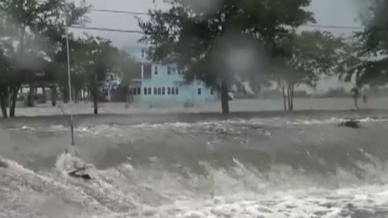
In Mandeville, a city on the north shore of Lake Pontchartrain across from New Orleans, storm surge and choppy waters sent waves pushing over the seawall and into nearby communities. Elsewhere, Coast Guard helicopters rescued a dozen people and two pets from flooded areas of Terrebonne Parish, south of New Orleans, some of them from rooftops, a spokeswoman said.
More than 140,000 customers in Louisiana and another more than 4,000 customers in Mississippi were without power early Sunday, according to poweroutage.us.

Barry Williams talks to a friend on his smartphone as he wades through storm surge from Lake Pontchartrain on Lakeshore Drive in Mandeville, La. (AP Photo/Matthew Hinton)
Barry was expected to continue weakening and become a tropical depression Sunday, moving over Arkansas on Sunday night and Monday. But forecasts showed the storm on a path toward Chicago that would swell the Mississippi River basin.
Reichmuth said on "FOX & friends" that another thing to keep in mind is that the storm took place at earlier part of the hurricane season as the Mississippi River has been above flood stage for over 200 days due to all the moisture from the winter and spring still traveling downriver. The threat for flooding in the region could still persist when the season ramps up in August and September.
"If we have a storm again, a stronger storm into August or September, we could talk about this same situation," he said.

True Crime
The hottest stories ripped from the headlines, from crime to courts, legal and scandal.
By entering your email and clicking the Subscribe button, you agree to the Fox News Privacy Policy and Terms of Use, and agree to receive content and promotional communications from Fox News. You understand that you can opt-out at any time.
